You are here: Home > Network List > TA - USArray Transportable Network (new EarthScope stations) Stations List
> Station O48A Farmland, IN, USA > Earthquake Result Viewer
O48A Farmland, IN, USA - Earthquake Result Viewer
| Earthquake location: |
Near Coast Of Northern Chile |
| Earthquake latitude/longitude: |
-20.6/-70.7 |
| Earthquake time(UTC): |
2014/04/04 (094) 01:37:51 GMT |
| Earthquake Depth: |
20 km |
| Earthquake Magnitude: |
6.1 MWP, 6.1 MWB, 6.1 MWW, 6.3 MWC |
| Earthquake Catalog/Contributor: |
NEIC PDE/NEIC COMCAT |
|
| Network: |
TA USArray Transportable Network (new EarthScope stations) |
| Station: |
O48A Farmland, IN, USA |
| Lat/Lon: |
40.26 N/85.16 W |
| Elevation: |
300 m |
|
| Distance: |
62.0 deg |
| Az: |
347.543 deg |
| Baz: |
164.691 deg |
| Ray Param: |
0.06046957 |
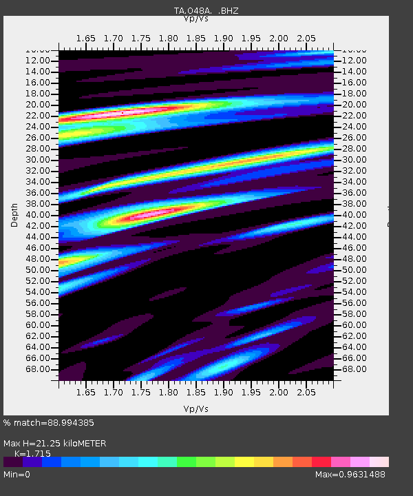
| Estimated Moho Depth: |
21.25 km |
| Estimated Crust Vp/Vs: |
1.72 |
| Assumed Crust Vp: |
6.498 km/s |
| Estimated Crust Vs: |
3.789 km/s |
| Estimated Crust Poisson's Ratio: |
0.24 |
|
| Radial Match: |
88.994385 % |
| Radial Bump: |
345 |
| Transverse Match: |
68.18723 % |
| Transverse Bump: |
400 |
| SOD ConfigId: |
626651 |
| Insert Time: |
2014-04-22 10:00:11.863 +0000 |
| GWidth: |
2.5 |
| Max Bumps: |
400 |
| Tol: |
0.001 |
|
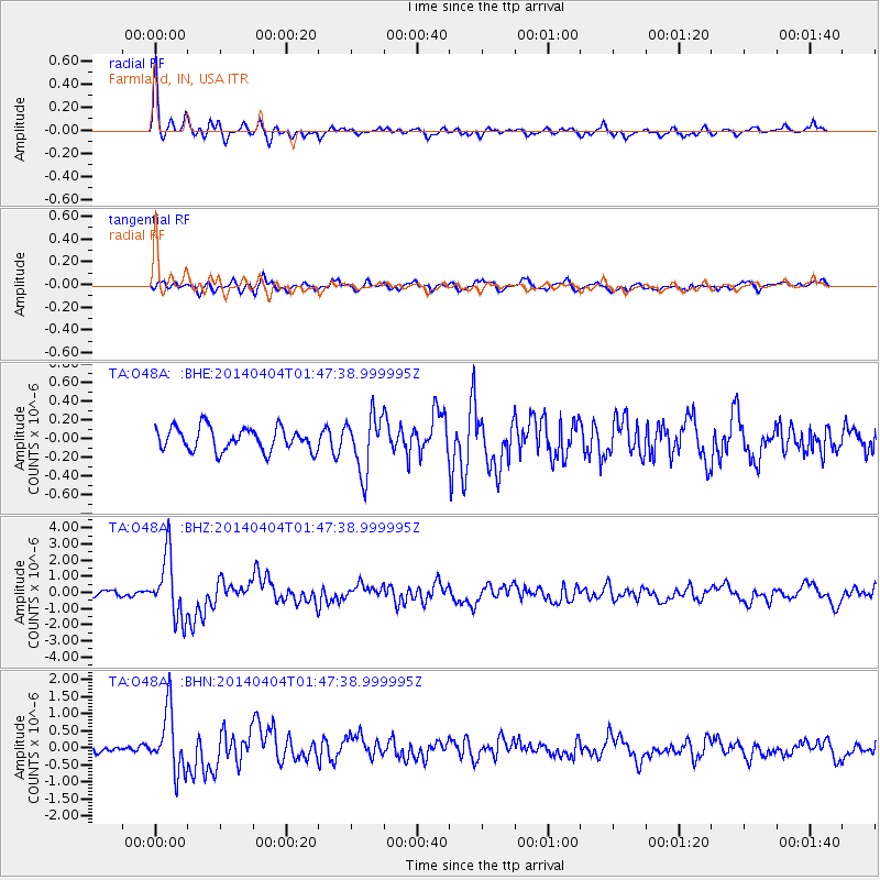
Signal To Noise
| Channel | StoN | STA | LTA |
| TA:O48A: :BHZ:20140404T01:47:38.999995Z | 14.21651 | 1.9095557E-6 | 1.3431959E-7 |
| TA:O48A: :BHN:20140404T01:47:38.999995Z | 10.57819 | 8.908876E-7 | 8.421929E-8 |
| TA:O48A: :BHE:20140404T01:47:38.999995Z | 2.4592352 | 3.0105545E-7 | 1.2241831E-7 |
| Arrivals |
| Ps | 2.5 SECOND |
| PpPs | 8.5 SECOND |
| PsPs/PpSs | 11 SECOND |


