You are here: Home > Network List > TA - USArray Transportable Network (new EarthScope stations) Stations List
> Station O49A Covington, OH, USA > Earthquake Result Viewer
O49A Covington, OH, USA - Earthquake Result Viewer
| Earthquake location: |
Near Coast Of Northern Chile |
| Earthquake latitude/longitude: |
-20.6/-70.7 |
| Earthquake time(UTC): |
2014/04/04 (094) 01:37:51 GMT |
| Earthquake Depth: |
20 km |
| Earthquake Magnitude: |
6.1 MWP, 6.1 MWB, 6.1 MWW, 6.3 MWC |
| Earthquake Catalog/Contributor: |
NEIC PDE/NEIC COMCAT |
|
| Network: |
TA USArray Transportable Network (new EarthScope stations) |
| Station: |
O49A Covington, OH, USA |
| Lat/Lon: |
40.19 N/84.34 W |
| Elevation: |
292 m |
|
| Distance: |
61.8 deg |
| Az: |
348.21 deg |
| Baz: |
165.532 deg |
| Ray Param: |
0.06061677 |
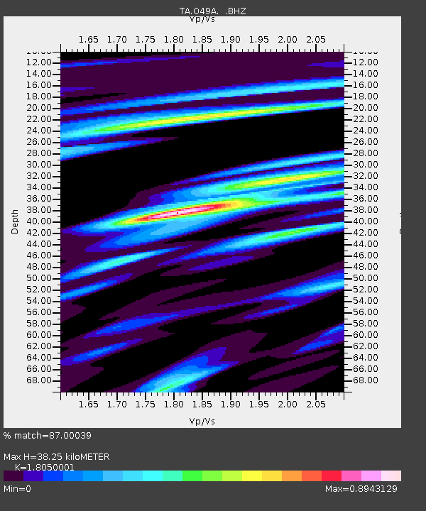
| Estimated Moho Depth: |
38.25 km |
| Estimated Crust Vp/Vs: |
1.81 |
| Assumed Crust Vp: |
6.498 km/s |
| Estimated Crust Vs: |
3.6 km/s |
| Estimated Crust Poisson's Ratio: |
0.28 |
|
| Radial Match: |
87.00039 % |
| Radial Bump: |
400 |
| Transverse Match: |
72.95784 % |
| Transverse Bump: |
400 |
| SOD ConfigId: |
626651 |
| Insert Time: |
2014-04-22 10:00:13.198 +0000 |
| GWidth: |
2.5 |
| Max Bumps: |
400 |
| Tol: |
0.001 |
|

Signal To Noise
| Channel | StoN | STA | LTA |
| TA:O49A: :BHZ:20140404T01:47:37.474971Z | 8.720927 | 1.5074594E-6 | 1.7285541E-7 |
| TA:O49A: :BHN:20140404T01:47:37.474971Z | 5.2033253 | 7.315576E-7 | 1.4059425E-7 |
| TA:O49A: :BHE:20140404T01:47:37.474971Z | 1.3257514 | 1.382545E-7 | 1.0428388E-7 |
| Arrivals |
| Ps | 5.0 SECOND |
| PpPs | 16 SECOND |
| PsPs/PpSs | 21 SECOND |


