You are here: Home > Network List > TA - USArray Transportable Network (new EarthScope stations) Stations List
> Station P54A Burton, WV, USA > Earthquake Result Viewer
P54A Burton, WV, USA - Earthquake Result Viewer
| Earthquake location: |
Near Coast Of Northern Chile |
| Earthquake latitude/longitude: |
-20.6/-70.7 |
| Earthquake time(UTC): |
2014/04/04 (094) 01:37:51 GMT |
| Earthquake Depth: |
20 km |
| Earthquake Magnitude: |
6.1 MWP, 6.1 MWB, 6.1 MWW, 6.3 MWC |
| Earthquake Catalog/Contributor: |
NEIC PDE/NEIC COMCAT |
|
| Network: |
TA USArray Transportable Network (new EarthScope stations) |
| Station: |
P54A Burton, WV, USA |
| Lat/Lon: |
39.61 N/80.48 W |
| Elevation: |
473 m |
|
| Distance: |
60.6 deg |
| Az: |
351.373 deg |
| Baz: |
169.52 deg |
| Ray Param: |
0.061400265 |
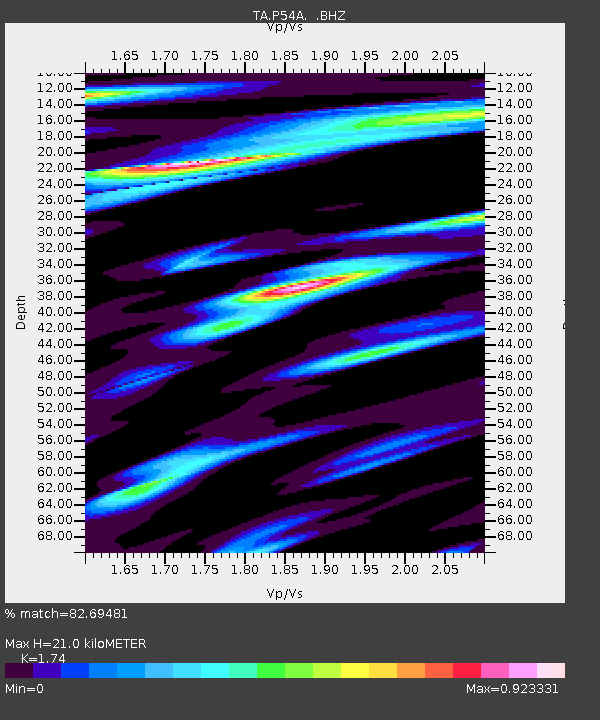
| Estimated Moho Depth: |
21.0 km |
| Estimated Crust Vp/Vs: |
1.74 |
| Assumed Crust Vp: |
6.207 km/s |
| Estimated Crust Vs: |
3.567 km/s |
| Estimated Crust Poisson's Ratio: |
0.25 |
|
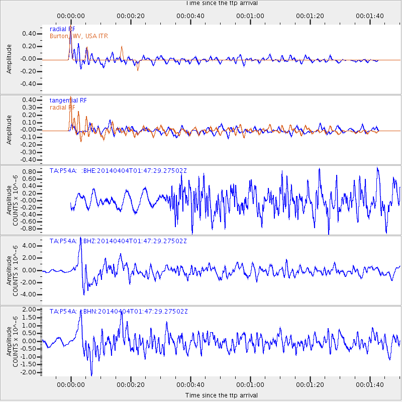
| Radial Match: |
82.69481 % |
| Radial Bump: |
400 |
| Transverse Match: |
68.871506 % |
| Transverse Bump: |
400 |
| SOD ConfigId: |
626651 |
| Insert Time: |
2014-04-22 10:01:04.073 +0000 |
| GWidth: |
2.5 |
| Max Bumps: |
400 |
| Tol: |
0.001 |
|
Signal To Noise
| Channel | StoN | STA | LTA |
| TA:P54A: :BHZ:20140404T01:47:29.27502Z | 12.52623 | 2.212412E-6 | 1.7662234E-7 |
| TA:P54A: :BHN:20140404T01:47:29.27502Z | 5.177275 | 8.3564527E-7 | 1.6140639E-7 |
| TA:P54A: :BHE:20140404T01:47:29.27502Z | 0.91905487 | 1.6512143E-7 | 1.796644E-7 |
| Arrivals |
| Ps | 2.6 SECOND |
| PpPs | 8.9 SECOND |
| PsPs/PpSs | 11 SECOND |


