You are here: Home > Network List > TA - USArray Transportable Network (new EarthScope stations) Stations List
> Station R54A Victor, WV, USA > Earthquake Result Viewer
R54A Victor, WV, USA - Earthquake Result Viewer
| Earthquake location: |
Near Coast Of Northern Chile |
| Earthquake latitude/longitude: |
-20.6/-70.7 |
| Earthquake time(UTC): |
2014/04/04 (094) 01:37:51 GMT |
| Earthquake Depth: |
20 km |
| Earthquake Magnitude: |
6.1 MWP, 6.1 MWB, 6.1 MWW, 6.3 MWC |
| Earthquake Catalog/Contributor: |
NEIC PDE/NEIC COMCAT |
|
| Network: |
TA USArray Transportable Network (new EarthScope stations) |
| Station: |
R54A Victor, WV, USA |
| Lat/Lon: |
38.18 N/80.99 W |
| Elevation: |
512 m |
|
| Distance: |
59.3 deg |
| Az: |
350.611 deg |
| Baz: |
168.819 deg |
| Ray Param: |
0.062271446 |
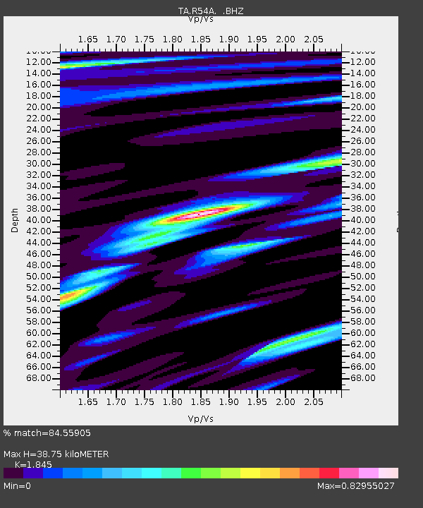
| Estimated Moho Depth: |
38.75 km |
| Estimated Crust Vp/Vs: |
1.85 |
| Assumed Crust Vp: |
6.207 km/s |
| Estimated Crust Vs: |
3.364 km/s |
| Estimated Crust Poisson's Ratio: |
0.29 |
|
| Radial Match: |
84.55905 % |
| Radial Bump: |
400 |
| Transverse Match: |
71.9679 % |
| Transverse Bump: |
400 |
| SOD ConfigId: |
626651 |
| Insert Time: |
2014-04-22 10:02:20.553 +0000 |
| GWidth: |
2.5 |
| Max Bumps: |
400 |
| Tol: |
0.001 |
|

Signal To Noise
| Channel | StoN | STA | LTA |
| TA:R54A: :BHZ:20140404T01:47:20.249995Z | 8.061162 | 1.9124143E-6 | 2.3723804E-7 |
| TA:R54A: :BHN:20140404T01:47:20.249995Z | 5.1490293 | 6.924225E-7 | 1.3447631E-7 |
| TA:R54A: :BHE:20140404T01:47:20.249995Z | 0.40444216 | 5.8221506E-8 | 1.4395509E-7 |
| Arrivals |
| Ps | 5.5 SECOND |
| PpPs | 17 SECOND |
| PsPs/PpSs | 23 SECOND |


