You are here: Home > Network List > TA - USArray Transportable Network (new EarthScope stations) Stations List
> Station R55A Marlinton, WV, USA > Earthquake Result Viewer
R55A Marlinton, WV, USA - Earthquake Result Viewer
| Earthquake location: |
Near Coast Of Northern Chile |
| Earthquake latitude/longitude: |
-20.6/-70.7 |
| Earthquake time(UTC): |
2014/04/04 (094) 01:37:51 GMT |
| Earthquake Depth: |
20 km |
| Earthquake Magnitude: |
6.1 MWP, 6.1 MWB, 6.1 MWW, 6.3 MWC |
| Earthquake Catalog/Contributor: |
NEIC PDE/NEIC COMCAT |
|
| Network: |
TA USArray Transportable Network (new EarthScope stations) |
| Station: |
R55A Marlinton, WV, USA |
| Lat/Lon: |
38.28 N/80.12 W |
| Elevation: |
833 m |
|
| Distance: |
59.2 deg |
| Az: |
351.417 deg |
| Baz: |
169.767 deg |
| Ray Param: |
0.062289804 |
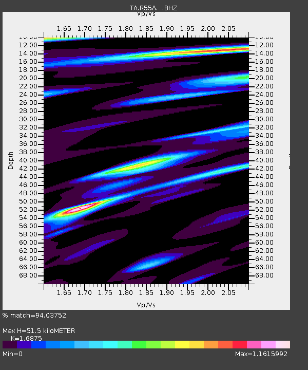
| Estimated Moho Depth: |
51.5 km |
| Estimated Crust Vp/Vs: |
1.69 |
| Assumed Crust Vp: |
6.207 km/s |
| Estimated Crust Vs: |
3.678 km/s |
| Estimated Crust Poisson's Ratio: |
0.23 |
|
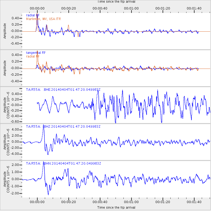
| Radial Match: |
94.03752 % |
| Radial Bump: |
400 |
| Transverse Match: |
85.60589 % |
| Transverse Bump: |
340 |
| SOD ConfigId: |
626651 |
| Insert Time: |
2014-04-22 10:02:22.275 +0000 |
| GWidth: |
2.5 |
| Max Bumps: |
400 |
| Tol: |
0.001 |
|
Signal To Noise
| Channel | StoN | STA | LTA |
| TA:R55A: :BHZ:20140404T01:47:20.049983Z | 17.029861 | 2.0749114E-6 | 1.2183959E-7 |
| TA:R55A: :BHN:20140404T01:47:20.049983Z | 10.892179 | 9.899529E-7 | 9.088659E-8 |
| TA:R55A: :BHE:20140404T01:47:20.049983Z | 0.61802995 | 8.175238E-8 | 1.3227898E-7 |
| Arrivals |
| Ps | 6.0 SECOND |
| PpPs | 21 SECOND |
| PsPs/PpSs | 27 SECOND |


