You are here: Home > Network List > TA - USArray Transportable Network (new EarthScope stations) Stations List
> Station S50A Richmond, KY, USA > Earthquake Result Viewer
S50A Richmond, KY, USA - Earthquake Result Viewer
| Earthquake location: |
Near Coast Of Northern Chile |
| Earthquake latitude/longitude: |
-20.6/-70.7 |
| Earthquake time(UTC): |
2014/04/04 (094) 01:37:51 GMT |
| Earthquake Depth: |
20 km |
| Earthquake Magnitude: |
6.1 MWP, 6.1 MWB, 6.1 MWW, 6.3 MWC |
| Earthquake Catalog/Contributor: |
NEIC PDE/NEIC COMCAT |
|
| Network: |
TA USArray Transportable Network (new EarthScope stations) |
| Station: |
S50A Richmond, KY, USA |
| Lat/Lon: |
37.68 N/84.40 W |
| Elevation: |
300 m |
|
| Distance: |
59.4 deg |
| Az: |
347.425 deg |
| Baz: |
165.106 deg |
| Ray Param: |
0.062191874 |
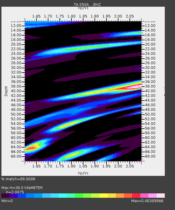
| Estimated Moho Depth: |
38.0 km |
| Estimated Crust Vp/Vs: |
2.09 |
| Assumed Crust Vp: |
6.476 km/s |
| Estimated Crust Vs: |
3.102 km/s |
| Estimated Crust Poisson's Ratio: |
0.35 |
|
| Radial Match: |
89.8089 % |
| Radial Bump: |
317 |
| Transverse Match: |
77.97639 % |
| Transverse Bump: |
400 |
| SOD ConfigId: |
626651 |
| Insert Time: |
2014-04-22 10:02:47.745 +0000 |
| GWidth: |
2.5 |
| Max Bumps: |
400 |
| Tol: |
0.001 |
|
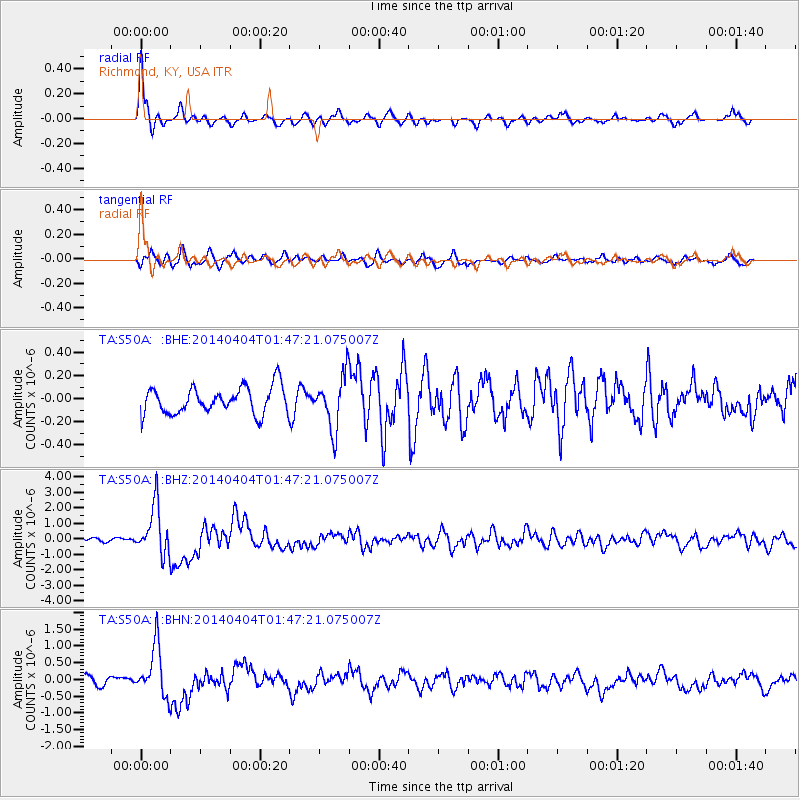
Signal To Noise
| Channel | StoN | STA | LTA |
| TA:S50A: :BHZ:20140404T01:47:21.075007Z | 14.607913 | 1.5812628E-6 | 1.0824701E-7 |
| TA:S50A: :BHN:20140404T01:47:21.075007Z | 7.3249927 | 7.531894E-7 | 1.0282459E-7 |
| TA:S50A: :BHE:20140404T01:47:21.075007Z | 2.0123692 | 2.3198535E-7 | 1.1527972E-7 |
| Arrivals |
| Ps | 6.6 SECOND |
| PpPs | 17 SECOND |
| PsPs/PpSs | 24 SECOND |


