You are here: Home > Network List > TA - USArray Transportable Network (new EarthScope stations) Stations List
> Station S57A Dark Hollow, Roseland, VA, USA > Earthquake Result Viewer
S57A Dark Hollow, Roseland, VA, USA - Earthquake Result Viewer
| Earthquake location: |
Near Coast Of Northern Chile |
| Earthquake latitude/longitude: |
-20.6/-70.7 |
| Earthquake time(UTC): |
2014/04/04 (094) 01:37:51 GMT |
| Earthquake Depth: |
20 km |
| Earthquake Magnitude: |
6.1 MWP, 6.1 MWB, 6.1 MWW, 6.3 MWC |
| Earthquake Catalog/Contributor: |
NEIC PDE/NEIC COMCAT |
|
| Network: |
TA USArray Transportable Network (new EarthScope stations) |
| Station: |
S57A Dark Hollow, Roseland, VA, USA |
| Lat/Lon: |
37.76 N/78.95 W |
| Elevation: |
264 m |
|
| Distance: |
58.6 deg |
| Az: |
352.375 deg |
| Baz: |
170.977 deg |
| Ray Param: |
0.06272756 |
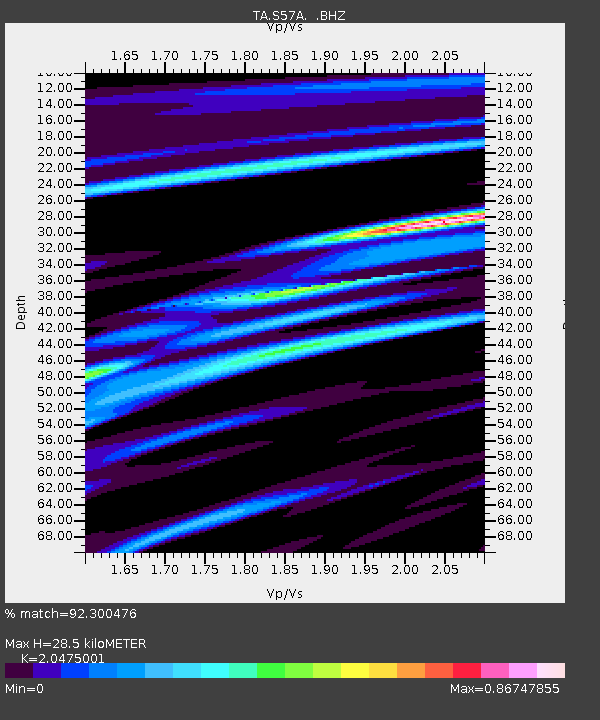
| Estimated Moho Depth: |
28.5 km |
| Estimated Crust Vp/Vs: |
2.05 |
| Assumed Crust Vp: |
6.419 km/s |
| Estimated Crust Vs: |
3.135 km/s |
| Estimated Crust Poisson's Ratio: |
0.34 |
|
| Radial Match: |
92.300476 % |
| Radial Bump: |
366 |
| Transverse Match: |
56.109463 % |
| Transverse Bump: |
400 |
| SOD ConfigId: |
626651 |
| Insert Time: |
2014-04-22 10:03:04.141 +0000 |
| GWidth: |
2.5 |
| Max Bumps: |
400 |
| Tol: |
0.001 |
|
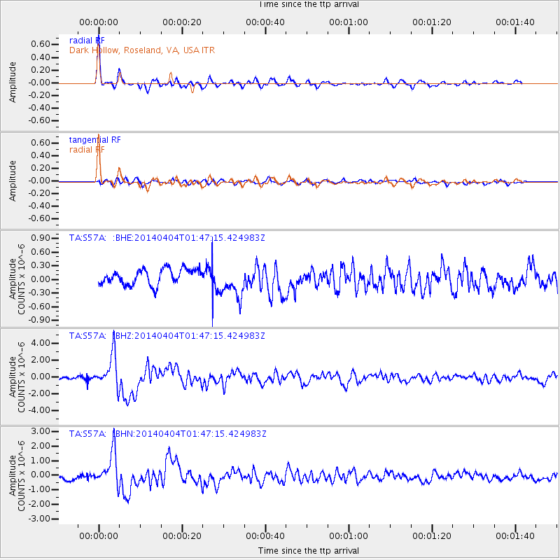
Signal To Noise
| Channel | StoN | STA | LTA |
| TA:S57A: :BHZ:20140404T01:47:15.424983Z | 12.869943 | 2.0105865E-6 | 1.5622344E-7 |
| TA:S57A: :BHN:20140404T01:47:15.424983Z | 10.40584 | 1.2424159E-6 | 1.1939602E-7 |
| TA:S57A: :BHE:20140404T01:47:15.424983Z | 2.1651454 | 3.6326955E-7 | 1.6778068E-7 |
| Arrivals |
| Ps | 4.8 SECOND |
| PpPs | 13 SECOND |
| PsPs/PpSs | 18 SECOND |


