You are here: Home > Network List > MX - Mexican National Seismic Network Stations List
> Station MOIG Morelia, Mich, MX > Earthquake Result Viewer
MOIG Morelia, Mich, MX - Earthquake Result Viewer
| Earthquake location: |
Mendoza Province, Argentina |
| Earthquake latitude/longitude: |
-32.7/-67.1 |
| Earthquake time(UTC): |
2015/02/02 (033) 10:49:48 GMT |
| Earthquake Depth: |
172 km |
| Earthquake Magnitude: |
6.3 MO |
| Earthquake Catalog/Contributor: |
NEIC PDE/NEIC ALERT |
|
| Network: |
MX Mexican National Seismic Network |
| Station: |
MOIG Morelia, Mich, MX |
| Lat/Lon: |
19.65 N/101.23 W |
| Elevation: |
2000 m |
|
| Distance: |
61.5 deg |
| Az: |
322.954 deg |
| Baz: |
147.393 deg |
| Ray Param: |
0.06033366 |
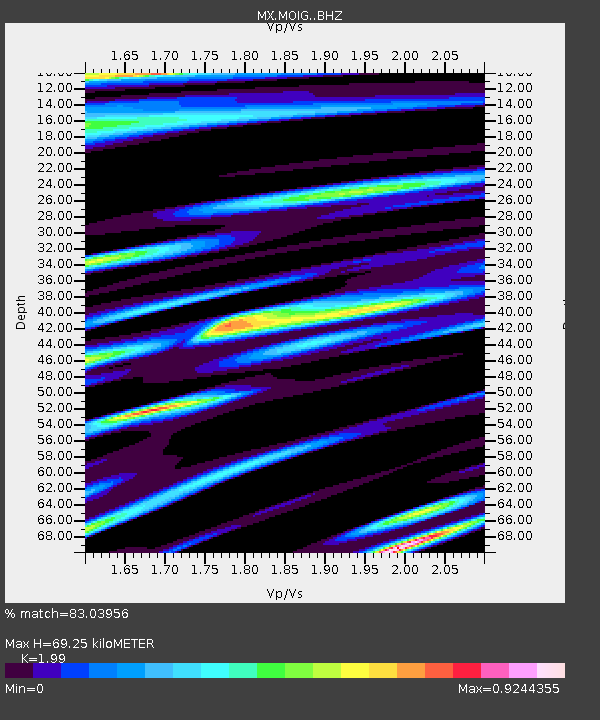
| Estimated Moho Depth: |
69.25 km |
| Estimated Crust Vp/Vs: |
1.99 |
| Assumed Crust Vp: |
6.566 km/s |
| Estimated Crust Vs: |
3.3 km/s |
| Estimated Crust Poisson's Ratio: |
0.33 |
|
| Radial Match: |
83.03956 % |
| Radial Bump: |
400 |
| Transverse Match: |
76.693436 % |
| Transverse Bump: |
400 |
| SOD ConfigId: |
6979251 |
| Insert Time: |
2019-04-16 11:20:40.644 +0000 |
| GWidth: |
2.5 |
| Max Bumps: |
400 |
| Tol: |
0.001 |
|

Signal To Noise
| Channel | StoN | STA | LTA |
| MX:MOIG: :BHZ:20150202T10:59:15.298022Z | 22.140043 | 4.6604196E-6 | 2.1049732E-7 |
| MX:MOIG: :BHN:20150202T10:59:15.298022Z | 4.6905622 | 1.0375322E-6 | 2.211957E-7 |
| MX:MOIG: :BHE:20150202T10:59:15.298022Z | 9.107176 | 1.7808271E-6 | 1.955411E-7 |
| Arrivals |
| Ps | 11 SECOND |
| PpPs | 30 SECOND |
| PsPs/PpSs | 41 SECOND |


