You are here: Home > Network List > TA - USArray Transportable Network (new EarthScope stations) Stations List
> Station T55A Pulaski, VA, USA > Earthquake Result Viewer
T55A Pulaski, VA, USA - Earthquake Result Viewer
| Earthquake location: |
Near Coast Of Northern Chile |
| Earthquake latitude/longitude: |
-20.6/-70.7 |
| Earthquake time(UTC): |
2014/04/04 (094) 01:37:51 GMT |
| Earthquake Depth: |
20 km |
| Earthquake Magnitude: |
6.1 MWP, 6.1 MWB, 6.1 MWW, 6.3 MWC |
| Earthquake Catalog/Contributor: |
NEIC PDE/NEIC COMCAT |
|
| Network: |
TA USArray Transportable Network (new EarthScope stations) |
| Station: |
T55A Pulaski, VA, USA |
| Lat/Lon: |
37.12 N/80.78 W |
| Elevation: |
644 m |
|
| Distance: |
58.2 deg |
| Az: |
350.558 deg |
| Baz: |
168.917 deg |
| Ray Param: |
0.062973954 |
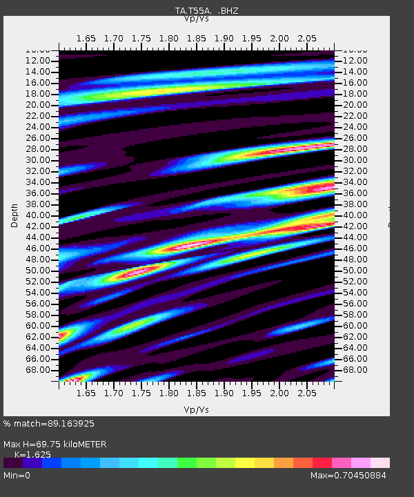
| Estimated Moho Depth: |
69.75 km |
| Estimated Crust Vp/Vs: |
1.62 |
| Assumed Crust Vp: |
6.159 km/s |
| Estimated Crust Vs: |
3.79 km/s |
| Estimated Crust Poisson's Ratio: |
0.20 |
|
| Radial Match: |
89.163925 % |
| Radial Bump: |
400 |
| Transverse Match: |
74.954735 % |
| Transverse Bump: |
400 |
| SOD ConfigId: |
626651 |
| Insert Time: |
2014-04-22 10:03:48.706 +0000 |
| GWidth: |
2.5 |
| Max Bumps: |
400 |
| Tol: |
0.001 |
|

Signal To Noise
| Channel | StoN | STA | LTA |
| TA:T55A: :BHZ:20140404T01:47:12.77502Z | 12.340021 | 2.0692664E-6 | 1.6768742E-7 |
| TA:T55A: :BHN:20140404T01:47:12.77502Z | 5.6477613 | 9.557926E-7 | 1.692339E-7 |
| TA:T55A: :BHE:20140404T01:47:12.77502Z | 1.9979726 | 2.4780576E-7 | 1.2402862E-7 |
| Arrivals |
| Ps | 7.4 SECOND |
| PpPs | 28 SECOND |
| PsPs/PpSs | 36 SECOND |


