You are here: Home > Network List > TA - USArray Transportable Network (new EarthScope stations) Stations List
> Station U55A TA2, Sparta, NC, USA > Earthquake Result Viewer
U55A TA2, Sparta, NC, USA - Earthquake Result Viewer
| Earthquake location: |
Near Coast Of Northern Chile |
| Earthquake latitude/longitude: |
-20.6/-70.7 |
| Earthquake time(UTC): |
2014/04/04 (094) 01:37:51 GMT |
| Earthquake Depth: |
20 km |
| Earthquake Magnitude: |
6.1 MWP, 6.1 MWB, 6.1 MWW, 6.3 MWC |
| Earthquake Catalog/Contributor: |
NEIC PDE/NEIC COMCAT |
|
| Network: |
TA USArray Transportable Network (new EarthScope stations) |
| Station: |
U55A TA2, Sparta, NC, USA |
| Lat/Lon: |
36.50 N/81.05 W |
| Elevation: |
863 m |
|
| Distance: |
57.6 deg |
| Az: |
350.173 deg |
| Baz: |
168.555 deg |
| Ray Param: |
0.063337155 |
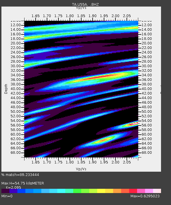
| Estimated Moho Depth: |
54.75 km |
| Estimated Crust Vp/Vs: |
2.10 |
| Assumed Crust Vp: |
6.159 km/s |
| Estimated Crust Vs: |
2.94 km/s |
| Estimated Crust Poisson's Ratio: |
0.35 |
|
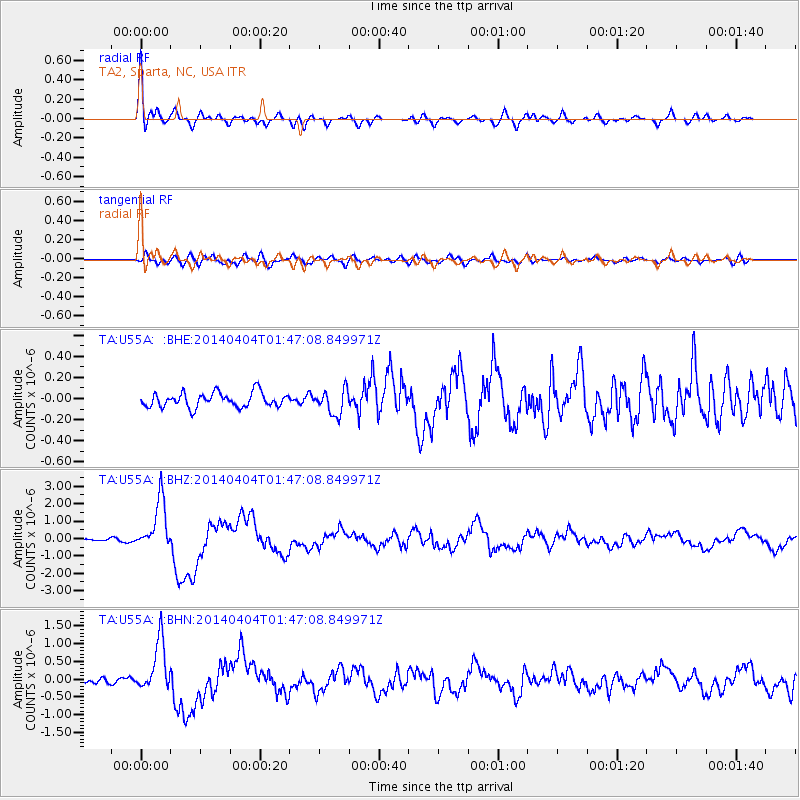
| Radial Match: |
89.233444 % |
| Radial Bump: |
400 |
| Transverse Match: |
73.14299 % |
| Transverse Bump: |
400 |
| SOD ConfigId: |
626651 |
| Insert Time: |
2014-04-22 10:04:14.930 +0000 |
| GWidth: |
2.5 |
| Max Bumps: |
400 |
| Tol: |
0.001 |
|
Signal To Noise
| Channel | StoN | STA | LTA |
| TA:U55A: :BHZ:20140404T01:47:08.849971Z | 20.391949 | 1.4349343E-6 | 7.036769E-8 |
| TA:U55A: :BHN:20140404T01:47:08.849971Z | 5.8726807 | 7.094479E-7 | 1.2080477E-7 |
| TA:U55A: :BHE:20140404T01:47:08.849971Z | 1.7211252 | 1.1733839E-7 | 6.817539E-8 |
| Arrivals |
| Ps | 10 SECOND |
| PpPs | 26 SECOND |
| PsPs/PpSs | 37 SECOND |


