You are here: Home > Network List > TA - USArray Transportable Network (new EarthScope stations) Stations List
> Station U60A Pendleton, NC, USA > Earthquake Result Viewer
U60A Pendleton, NC, USA - Earthquake Result Viewer
| Earthquake location: |
Near Coast Of Northern Chile |
| Earthquake latitude/longitude: |
-20.6/-70.7 |
| Earthquake time(UTC): |
2014/04/04 (094) 01:37:51 GMT |
| Earthquake Depth: |
20 km |
| Earthquake Magnitude: |
6.1 MWP, 6.1 MWB, 6.1 MWW, 6.3 MWC |
| Earthquake Catalog/Contributor: |
NEIC PDE/NEIC COMCAT |
|
| Network: |
TA USArray Transportable Network (new EarthScope stations) |
| Station: |
U60A Pendleton, NC, USA |
| Lat/Lon: |
36.47 N/77.16 W |
| Elevation: |
8.0 m |
|
| Distance: |
57.1 deg |
| Az: |
353.838 deg |
| Baz: |
172.834 deg |
| Ray Param: |
0.06367972 |
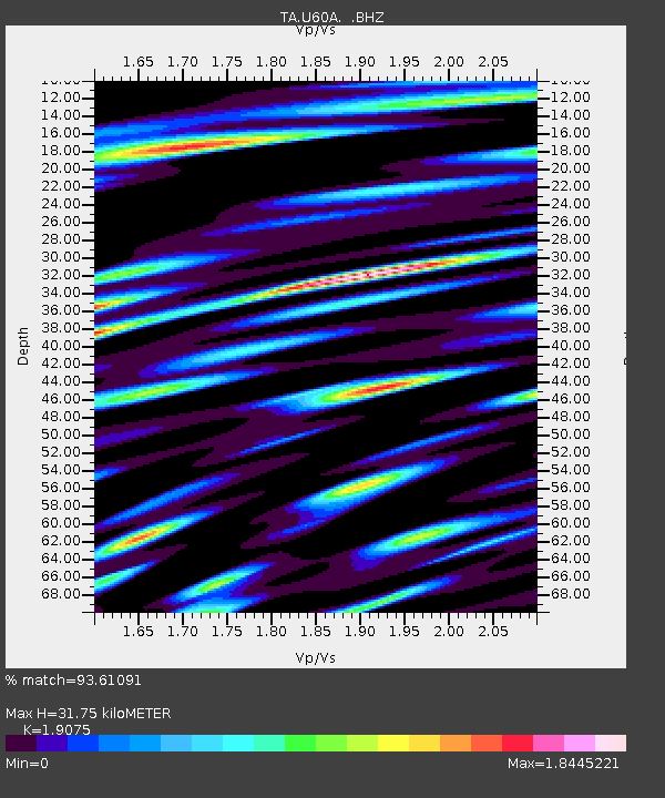
| Estimated Moho Depth: |
31.75 km |
| Estimated Crust Vp/Vs: |
1.91 |
| Assumed Crust Vp: |
6.565 km/s |
| Estimated Crust Vs: |
3.441 km/s |
| Estimated Crust Poisson's Ratio: |
0.31 |
|
| Radial Match: |
93.61091 % |
| Radial Bump: |
400 |
| Transverse Match: |
80.786835 % |
| Transverse Bump: |
400 |
| SOD ConfigId: |
626651 |
| Insert Time: |
2014-04-22 10:04:27.824 +0000 |
| GWidth: |
2.5 |
| Max Bumps: |
400 |
| Tol: |
0.001 |
|

Signal To Noise
| Channel | StoN | STA | LTA |
| TA:U60A: :BHZ:20140404T01:47:05.099971Z | 11.764916 | 2.165404E-6 | 1.8405606E-7 |
| TA:U60A: :BHN:20140404T01:47:05.099971Z | 8.379283 | 1.4344621E-6 | 1.711915E-7 |
| TA:U60A: :BHE:20140404T01:47:05.099971Z | 1.8307137 | 4.0380047E-7 | 2.2056997E-7 |
| Arrivals |
| Ps | 4.6 SECOND |
| PpPs | 13 SECOND |
| PsPs/PpSs | 18 SECOND |


