You are here: Home > Network List > TA - USArray Transportable Network (new EarthScope stations) Stations List
> Station V54A Nebo, NC, USA > Earthquake Result Viewer
V54A Nebo, NC, USA - Earthquake Result Viewer
| Earthquake location: |
Near Coast Of Northern Chile |
| Earthquake latitude/longitude: |
-20.6/-70.7 |
| Earthquake time(UTC): |
2014/04/04 (094) 01:37:51 GMT |
| Earthquake Depth: |
20 km |
| Earthquake Magnitude: |
6.1 MWP, 6.1 MWB, 6.1 MWW, 6.3 MWC |
| Earthquake Catalog/Contributor: |
NEIC PDE/NEIC COMCAT |
|
| Network: |
TA USArray Transportable Network (new EarthScope stations) |
| Station: |
V54A Nebo, NC, USA |
| Lat/Lon: |
35.78 N/81.95 W |
| Elevation: |
448 m |
|
| Distance: |
57.1 deg |
| Az: |
349.148 deg |
| Baz: |
167.474 deg |
| Ray Param: |
0.0636927 |
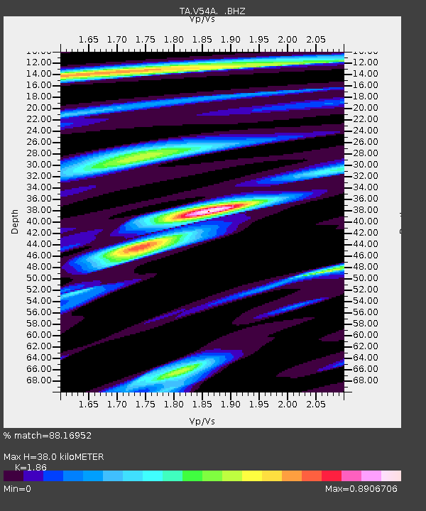
| Estimated Moho Depth: |
38.0 km |
| Estimated Crust Vp/Vs: |
1.86 |
| Assumed Crust Vp: |
6.419 km/s |
| Estimated Crust Vs: |
3.451 km/s |
| Estimated Crust Poisson's Ratio: |
0.30 |
|
| Radial Match: |
88.16952 % |
| Radial Bump: |
400 |
| Transverse Match: |
71.61094 % |
| Transverse Bump: |
400 |
| SOD ConfigId: |
626651 |
| Insert Time: |
2014-04-22 10:04:32.916 +0000 |
| GWidth: |
2.5 |
| Max Bumps: |
400 |
| Tol: |
0.001 |
|

Signal To Noise
| Channel | StoN | STA | LTA |
| TA:V54A: :BHZ:20140404T01:47:04.950007Z | 11.924901 | 1.5480258E-6 | 1.2981457E-7 |
| TA:V54A: :BHN:20140404T01:47:04.950007Z | 4.9486732 | 6.338391E-7 | 1.2808262E-7 |
| TA:V54A: :BHE:20140404T01:47:04.950007Z | 1.7203166 | 1.8681536E-7 | 1.0859359E-7 |
| Arrivals |
| Ps | 5.3 SECOND |
| PpPs | 16 SECOND |
| PsPs/PpSs | 21 SECOND |


