You are here: Home > Network List > TA - USArray Transportable Network (new EarthScope stations) Stations List
> Station V56A Mocksville, NC, USA > Earthquake Result Viewer
V56A Mocksville, NC, USA - Earthquake Result Viewer
| Earthquake location: |
Near Coast Of Northern Chile |
| Earthquake latitude/longitude: |
-20.6/-70.7 |
| Earthquake time(UTC): |
2014/04/04 (094) 01:37:51 GMT |
| Earthquake Depth: |
20 km |
| Earthquake Magnitude: |
6.1 MWP, 6.1 MWB, 6.1 MWW, 6.3 MWC |
| Earthquake Catalog/Contributor: |
NEIC PDE/NEIC COMCAT |
|
| Network: |
TA USArray Transportable Network (new EarthScope stations) |
| Station: |
V56A Mocksville, NC, USA |
| Lat/Lon: |
35.81 N/80.50 W |
| Elevation: |
237 m |
|
| Distance: |
56.9 deg |
| Az: |
350.533 deg |
| Baz: |
169.074 deg |
| Ray Param: |
0.06382934 |
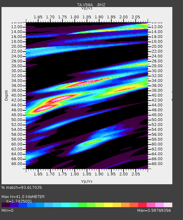
| Estimated Moho Depth: |
41.0 km |
| Estimated Crust Vp/Vs: |
1.74 |
| Assumed Crust Vp: |
6.419 km/s |
| Estimated Crust Vs: |
3.684 km/s |
| Estimated Crust Poisson's Ratio: |
0.25 |
|
| Radial Match: |
93.617035 % |
| Radial Bump: |
297 |
| Transverse Match: |
72.13735 % |
| Transverse Bump: |
400 |
| SOD ConfigId: |
626651 |
| Insert Time: |
2014-04-22 10:04:37.732 +0000 |
| GWidth: |
2.5 |
| Max Bumps: |
400 |
| Tol: |
0.001 |
|
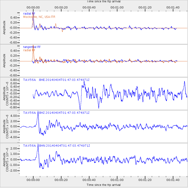
Signal To Noise
| Channel | StoN | STA | LTA |
| TA:V56A: :BHZ:20140404T01:47:03.474971Z | 12.858567 | 2.1102935E-6 | 1.6411575E-7 |
| TA:V56A: :BHN:20140404T01:47:03.474971Z | 10.624535 | 1.0552519E-6 | 9.932218E-8 |
| TA:V56A: :BHE:20140404T01:47:03.474971Z | 3.5465584 | 3.8658763E-7 | 1.090036E-7 |
| Arrivals |
| Ps | 5.0 SECOND |
| PpPs | 17 SECOND |
| PsPs/PpSs | 22 SECOND |


