You are here: Home > Network List > N4 - Central and EAstern US Network Stations List
> Station 735B Kenedy, TX, USA > Earthquake Result Viewer
735B Kenedy, TX, USA - Earthquake Result Viewer
| Earthquake location: |
Mendoza Province, Argentina |
| Earthquake latitude/longitude: |
-32.7/-67.1 |
| Earthquake time(UTC): |
2015/02/02 (033) 10:49:48 GMT |
| Earthquake Depth: |
172 km |
| Earthquake Magnitude: |
6.3 MO |
| Earthquake Catalog/Contributor: |
NEIC PDE/NEIC ALERT |
|
| Network: |
N4 Central and EAstern US Network |
| Station: |
735B Kenedy, TX, USA |
| Lat/Lon: |
28.86 N/97.81 W |
| Elevation: |
109 m |
|
| Distance: |
67.8 deg |
| Az: |
331.036 deg |
| Baz: |
152.265 deg |
| Ray Param: |
0.056217097 |
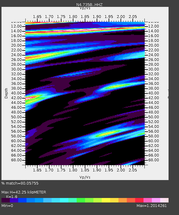
| Estimated Moho Depth: |
42.25 km |
| Estimated Crust Vp/Vs: |
1.60 |
| Assumed Crust Vp: |
5.78 km/s |
| Estimated Crust Vs: |
3.612 km/s |
| Estimated Crust Poisson's Ratio: |
0.18 |
|
| Radial Match: |
80.05755 % |
| Radial Bump: |
400 |
| Transverse Match: |
66.565315 % |
| Transverse Bump: |
400 |
| SOD ConfigId: |
6979251 |
| Insert Time: |
2019-04-16 11:21:45.889 +0000 |
| GWidth: |
2.5 |
| Max Bumps: |
400 |
| Tol: |
0.001 |
|

Signal To Noise
| Channel | StoN | STA | LTA |
| N4:735B: :HHZ:20150202T10:59:56.43999Z | 4.382924 | 6.143316E-6 | 1.4016479E-6 |
| N4:735B: :HHN:20150202T10:59:56.43999Z | 1.1495495 | 1.3315719E-6 | 1.1583425E-6 |
| N4:735B: :HHE:20150202T10:59:56.43999Z | 1.811383 | 1.462871E-6 | 8.075989E-7 |
| Arrivals |
| Ps | 4.5 SECOND |
| PpPs | 18 SECOND |
| PsPs/PpSs | 23 SECOND |


