You are here: Home > Network List > TA - USArray Transportable Network (new EarthScope stations) Stations List
> Station V57A Coltrane Farms, NC, USA > Earthquake Result Viewer
V57A Coltrane Farms, NC, USA - Earthquake Result Viewer
| Earthquake location: |
Near Coast Of Northern Chile |
| Earthquake latitude/longitude: |
-20.6/-70.7 |
| Earthquake time(UTC): |
2014/04/04 (094) 01:37:51 GMT |
| Earthquake Depth: |
20 km |
| Earthquake Magnitude: |
6.1 MWP, 6.1 MWB, 6.1 MWW, 6.3 MWC |
| Earthquake Catalog/Contributor: |
NEIC PDE/NEIC COMCAT |
|
| Network: |
TA USArray Transportable Network (new EarthScope stations) |
| Station: |
V57A Coltrane Farms, NC, USA |
| Lat/Lon: |
35.89 N/79.78 W |
| Elevation: |
223 m |
|
| Distance: |
56.8 deg |
| Az: |
351.238 deg |
| Baz: |
169.879 deg |
| Ray Param: |
0.06384943 |
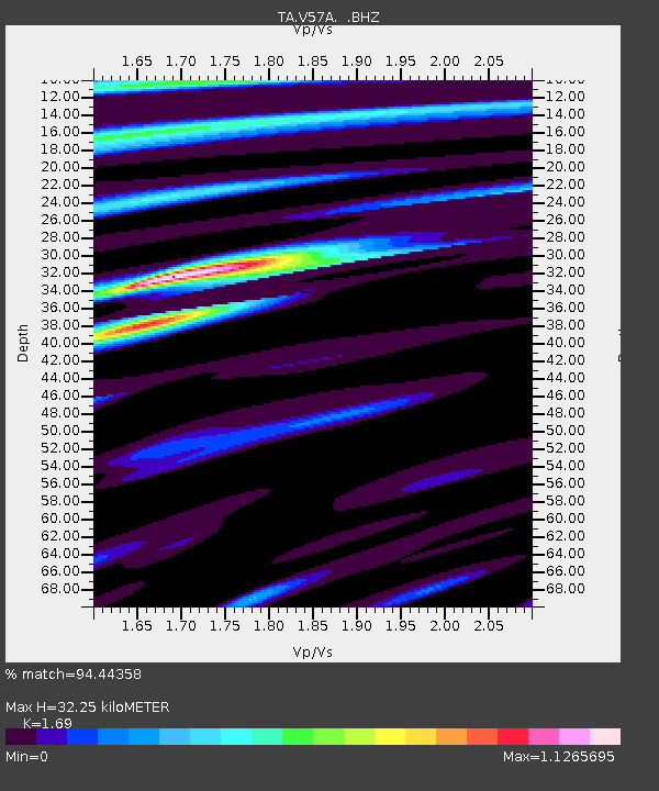
| Estimated Moho Depth: |
32.25 km |
| Estimated Crust Vp/Vs: |
1.69 |
| Assumed Crust Vp: |
6.565 km/s |
| Estimated Crust Vs: |
3.884 km/s |
| Estimated Crust Poisson's Ratio: |
0.23 |
|
| Radial Match: |
94.44358 % |
| Radial Bump: |
395 |
| Transverse Match: |
66.718895 % |
| Transverse Bump: |
400 |
| SOD ConfigId: |
626651 |
| Insert Time: |
2014-04-22 10:04:39.802 +0000 |
| GWidth: |
2.5 |
| Max Bumps: |
400 |
| Tol: |
0.001 |
|

Signal To Noise
| Channel | StoN | STA | LTA |
| TA:V57A: :BHZ:20140404T01:47:03.249995Z | 11.895702 | 1.8089396E-6 | 1.5206665E-7 |
| TA:V57A: :BHN:20140404T01:47:03.249995Z | 9.298451 | 7.2524983E-7 | 7.799684E-8 |
| TA:V57A: :BHE:20140404T01:47:03.249995Z | 1.4478054 | 1.8937027E-7 | 1.3079814E-7 |
| Arrivals |
| Ps | 3.6 SECOND |
| PpPs | 13 SECOND |
| PsPs/PpSs | 16 SECOND |


