You are here: Home > Network List > TA - USArray Transportable Network (new EarthScope stations) Stations List
> Station W39A Magazine, AR, USA > Earthquake Result Viewer
W39A Magazine, AR, USA - Earthquake Result Viewer

| Earthquake location: |
Near Coast Of Northern Chile |
| Earthquake latitude/longitude: |
-20.6/-70.7 |
| Earthquake time(UTC): |
2014/04/04 (094) 01:37:51 GMT |
| Earthquake Depth: |
20 km |
| Earthquake Magnitude: |
6.1 MWP, 6.1 MWB, 6.1 MWW, 6.3 MWC |
| Earthquake Catalog/Contributor: |
NEIC PDE/NEIC COMCAT |
|
| Network: |
TA USArray Transportable Network (new EarthScope stations) |
| Station: |
W39A Magazine, AR, USA |
| Lat/Lon: |
35.20 N/93.78 W |
| Elevation: |
162 m |
|
| Distance: |
59.7 deg |
| Az: |
338.195 deg |
| Baz: |
154.86 deg |
| Ray Param: |
0.062015563 |
| Estimated Moho Depth: |
37.25 km |
| Estimated Crust Vp/Vs: |
1.85 |
| Assumed Crust Vp: |
6.498 km/s |
| Estimated Crust Vs: |
3.522 km/s |
| Estimated Crust Poisson's Ratio: |
0.29 |
|
| Radial Match: |
83.514244 % |
| Radial Bump: |
400 |
| Transverse Match: |
76.34425 % |
| Transverse Bump: |
400 |
| SOD ConfigId: |
626651 |
| Insert Time: |
2014-04-22 10:04:57.216 +0000 |
| GWidth: |
2.5 |
| Max Bumps: |
400 |
| Tol: |
0.001 |
|
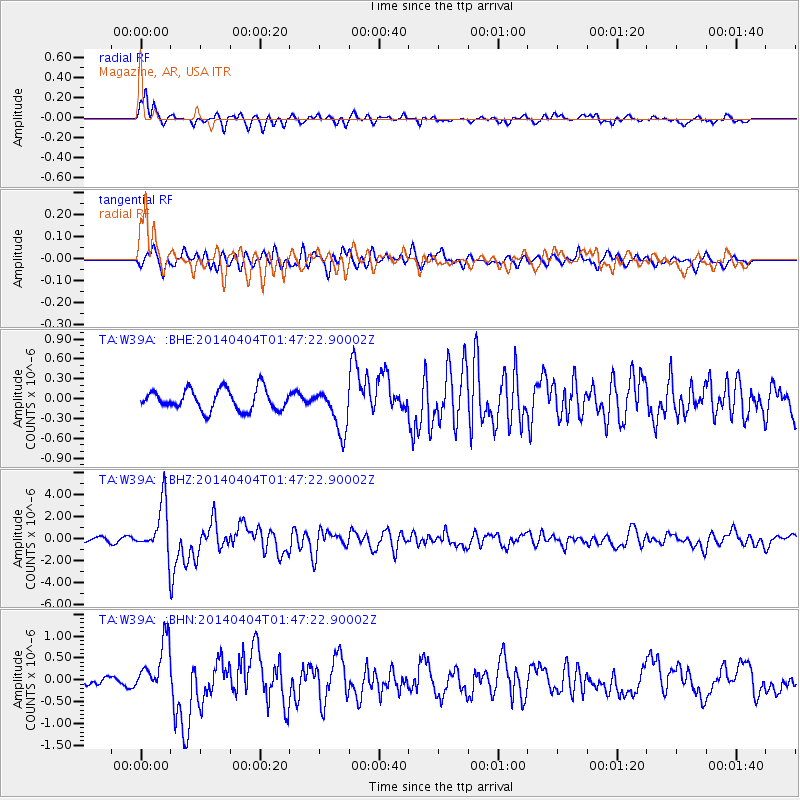
Signal To Noise
| Channel | StoN | STA | LTA |
| TA:W39A: :BHZ:20140404T01:47:22.90002Z | 12.210278 | 2.2839513E-6 | 1.8705154E-7 |
| TA:W39A: :BHN:20140404T01:47:22.90002Z | 7.464941 | 5.931882E-7 | 7.946321E-8 |
| TA:W39A: :BHE:20140404T01:47:22.90002Z | 2.1226895 | 3.3223222E-7 | 1.5651474E-7 |
| Arrivals |
| Ps | 5.1 SECOND |
| PpPs | 16 SECOND |
| PsPs/PpSs | 21 SECOND |


