You are here: Home > Network List > TA - USArray Transportable Network (new EarthScope stations) Stations List
> Station X53A Estanollee, GA, USA > Earthquake Result Viewer
X53A Estanollee, GA, USA - Earthquake Result Viewer
| Earthquake location: |
Near Coast Of Northern Chile |
| Earthquake latitude/longitude: |
-20.6/-70.7 |
| Earthquake time(UTC): |
2014/04/04 (094) 01:37:51 GMT |
| Earthquake Depth: |
20 km |
| Earthquake Magnitude: |
6.1 MWP, 6.1 MWB, 6.1 MWW, 6.3 MWC |
| Earthquake Catalog/Contributor: |
NEIC PDE/NEIC COMCAT |
|
| Network: |
TA USArray Transportable Network (new EarthScope stations) |
| Station: |
X53A Estanollee, GA, USA |
| Lat/Lon: |
34.50 N/83.30 W |
| Elevation: |
240 m |
|
| Distance: |
56.1 deg |
| Az: |
347.503 deg |
| Baz: |
165.793 deg |
| Ray Param: |
0.06433411 |
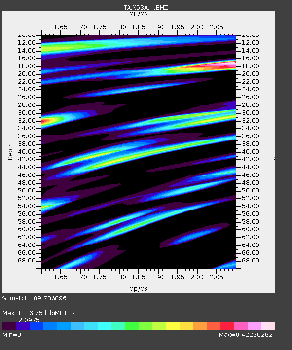
| Estimated Moho Depth: |
16.75 km |
| Estimated Crust Vp/Vs: |
2.10 |
| Assumed Crust Vp: |
6.35 km/s |
| Estimated Crust Vs: |
3.027 km/s |
| Estimated Crust Poisson's Ratio: |
0.35 |
|
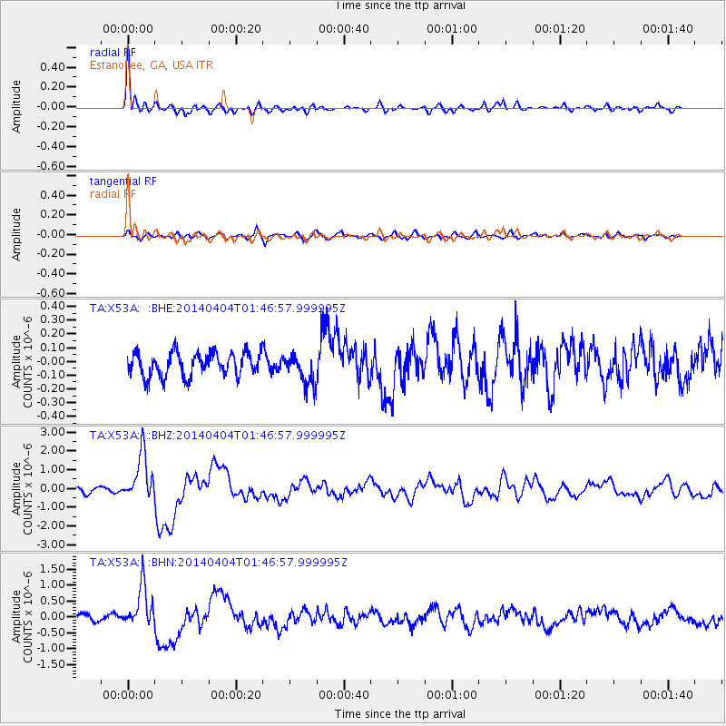
| Radial Match: |
89.786896 % |
| Radial Bump: |
400 |
| Transverse Match: |
51.605247 % |
| Transverse Bump: |
400 |
| SOD ConfigId: |
626651 |
| Insert Time: |
2014-04-22 10:05:28.747 +0000 |
| GWidth: |
2.5 |
| Max Bumps: |
400 |
| Tol: |
0.001 |
|
Signal To Noise
| Channel | StoN | STA | LTA |
| TA:X53A: :BHZ:20140404T01:46:57.999995Z | 9.21162 | 1.2510933E-6 | 1.3581686E-7 |
| TA:X53A: :BHN:20140404T01:46:57.999995Z | 6.9437733 | 6.6536404E-7 | 9.582168E-8 |
| TA:X53A: :BHE:20140404T01:46:57.999995Z | 1.2978927 | 1.1094335E-7 | 8.54796E-8 |
| Arrivals |
| Ps | 3.0 SECOND |
| PpPs | 7.8 SECOND |
| PsPs/PpSs | 11 SECOND |


