You are here: Home > Network List > TA - USArray Transportable Network (new EarthScope stations) Stations List
> Station X54A Belton, SC, USA > Earthquake Result Viewer
X54A Belton, SC, USA - Earthquake Result Viewer
| Earthquake location: |
Near Coast Of Northern Chile |
| Earthquake latitude/longitude: |
-20.6/-70.7 |
| Earthquake time(UTC): |
2014/04/04 (094) 01:37:51 GMT |
| Earthquake Depth: |
20 km |
| Earthquake Magnitude: |
6.1 MWP, 6.1 MWB, 6.1 MWW, 6.3 MWC |
| Earthquake Catalog/Contributor: |
NEIC PDE/NEIC COMCAT |
|
| Network: |
TA USArray Transportable Network (new EarthScope stations) |
| Station: |
X54A Belton, SC, USA |
| Lat/Lon: |
34.55 N/82.37 W |
| Elevation: |
213 m |
|
| Distance: |
56.0 deg |
| Az: |
348.412 deg |
| Baz: |
166.823 deg |
| Ray Param: |
0.06442409 |
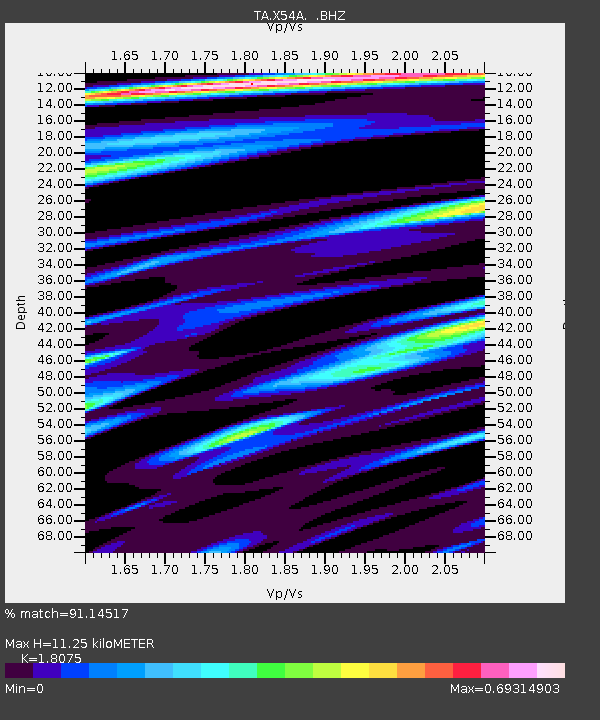
| Estimated Moho Depth: |
11.25 km |
| Estimated Crust Vp/Vs: |
1.81 |
| Assumed Crust Vp: |
6.35 km/s |
| Estimated Crust Vs: |
3.513 km/s |
| Estimated Crust Poisson's Ratio: |
0.28 |
|
| Radial Match: |
91.14517 % |
| Radial Bump: |
400 |
| Transverse Match: |
62.67453 % |
| Transverse Bump: |
400 |
| SOD ConfigId: |
626651 |
| Insert Time: |
2014-04-22 10:05:33.369 +0000 |
| GWidth: |
2.5 |
| Max Bumps: |
400 |
| Tol: |
0.001 |
|

Signal To Noise
| Channel | StoN | STA | LTA |
| TA:X54A: :BHZ:20140404T01:46:56.999995Z | 10.182328 | 1.4007893E-6 | 1.3757062E-7 |
| TA:X54A: :BHN:20140404T01:46:56.999995Z | 8.750797 | 7.423155E-7 | 8.482833E-8 |
| TA:X54A: :BHE:20140404T01:46:56.999995Z | 3.2446432 | 2.153309E-7 | 6.6365054E-8 |
| Arrivals |
| Ps | 1.5 SECOND |
| PpPs | 4.7 SECOND |
| PsPs/PpSs | 6.2 SECOND |


