You are here: Home > Network List > UU - University of Utah Regional Network Stations List
> Station HMU Henry Mountain, UT, USA > Earthquake Result Viewer
HMU Henry Mountain, UT, USA - Earthquake Result Viewer
| Earthquake location: |
Near Coast Of Northern Chile |
| Earthquake latitude/longitude: |
-20.6/-70.7 |
| Earthquake time(UTC): |
2014/04/04 (094) 01:37:51 GMT |
| Earthquake Depth: |
20 km |
| Earthquake Magnitude: |
6.1 MWP, 6.1 MWB, 6.1 MWW, 6.3 MWC |
| Earthquake Catalog/Contributor: |
NEIC PDE/NEIC COMCAT |
|
| Network: |
UU University of Utah Regional Network |
| Station: |
HMU Henry Mountain, UT, USA |
| Lat/Lon: |
37.94 N/110.74 W |
| Elevation: |
2430 m |
|
| Distance: |
69.3 deg |
| Az: |
327.096 deg |
| Baz: |
139.942 deg |
| Ray Param: |
0.05569816 |
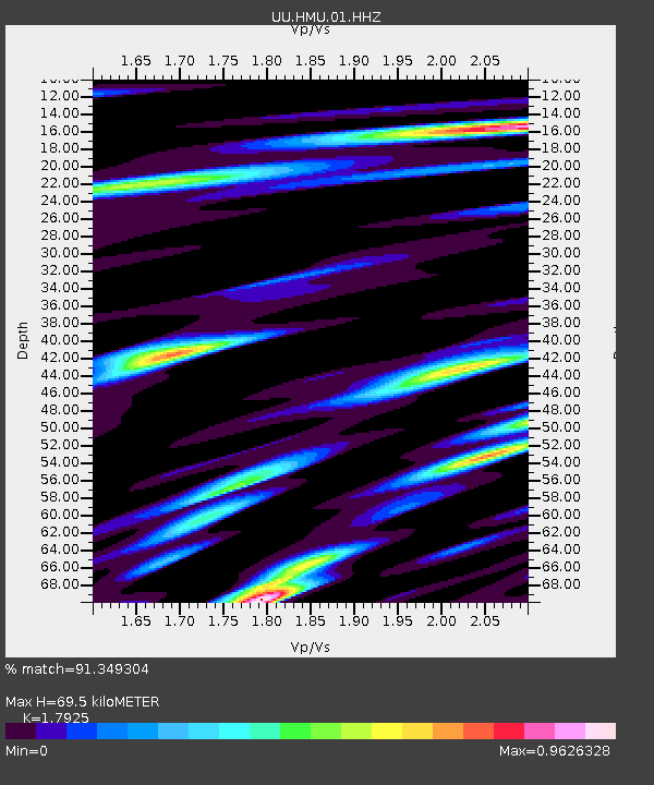
| Estimated Moho Depth: |
69.5 km |
| Estimated Crust Vp/Vs: |
1.79 |
| Assumed Crust Vp: |
6.247 km/s |
| Estimated Crust Vs: |
3.485 km/s |
| Estimated Crust Poisson's Ratio: |
0.27 |
|
| Radial Match: |
91.349304 % |
| Radial Bump: |
400 |
| Transverse Match: |
79.611534 % |
| Transverse Bump: |
400 |
| SOD ConfigId: |
626651 |
| Insert Time: |
2014-04-22 10:09:12.546 +0000 |
| GWidth: |
2.5 |
| Max Bumps: |
400 |
| Tol: |
0.001 |
|

Signal To Noise
| Channel | StoN | STA | LTA |
| UU:HMU:01:HHZ:20140404T01:48:25.950984Z | 1.9144535 | 1.1239297E-8 | 5.87076E-9 |
| UU:HMU:01:HHN:20140404T01:48:25.950984Z | 1.4285859 | 3.7157228E-9 | 2.6009794E-9 |
| UU:HMU:01:HHE:20140404T01:48:25.950984Z | 1.1611242 | 6.3055525E-9 | 5.4305582E-9 |
| Arrivals |
| Ps | 9.1 SECOND |
| PpPs | 30 SECOND |
| PsPs/PpSs | 39 SECOND |


