You are here: Home > Network List > IU - Global Seismograph Network (GSN - IRIS/USGS) Stations List
> Station AFI Afiamalu, Samoa > Earthquake Result Viewer
AFI Afiamalu, Samoa - Earthquake Result Viewer
| Earthquake location: |
Southern Sumatra, Indonesia |
| Earthquake latitude/longitude: |
-0.7/99.9 |
| Earthquake time(UTC): |
2009/09/30 (273) 10:16:09 GMT |
| Earthquake Depth: |
81 km |
| Earthquake Magnitude: |
7.1 MB, 7.5 MW, 7.5 MW |
| Earthquake Catalog/Contributor: |
WHDF/NEIC |
|
| Network: |
IU Global Seismograph Network (GSN - IRIS/USGS) |
| Station: |
AFI Afiamalu, Samoa |
| Lat/Lon: |
13.91 S/171.78 W |
| Elevation: |
706 m |
|
| Distance: |
88.2 deg |
| Az: |
103.805 deg |
| Baz: |
269.698 deg |
| Ray Param: |
0.042578775 |
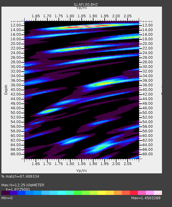
| Estimated Moho Depth: |
12.25 km |
| Estimated Crust Vp/Vs: |
1.87 |
| Assumed Crust Vp: |
4.24 km/s |
| Estimated Crust Vs: |
2.264 km/s |
| Estimated Crust Poisson's Ratio: |
0.30 |
|
| Radial Match: |
87.489334 % |
| Radial Bump: |
400 |
| Transverse Match: |
79.21978 % |
| Transverse Bump: |
400 |
| SOD ConfigId: |
1 |
| Insert Time: |
2010-02-19 00:24:54.390 +0000 |
| GWidth: |
2.5 |
| Max Bumps: |
400 |
| Tol: |
0.001 |
|
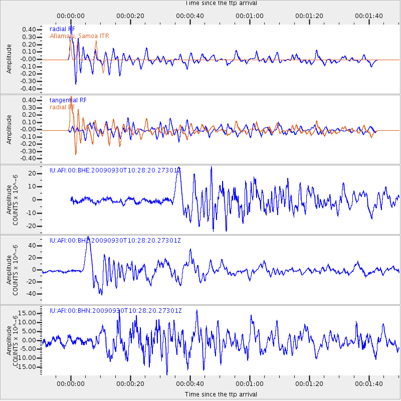
Signal To Noise
| Channel | StoN | STA | LTA |
| IU:AFI:00:BHZ:20090930T10:28:20.27301Z | 3.3633406 | 4.888165E-6 | 1.453366E-6 |
| IU:AFI:00:BHN:20090930T10:28:20.27301Z | 1.2192218 | 1.558741E-6 | 1.278472E-6 |
| IU:AFI:00:BHE:20090930T10:28:20.27301Z | 0.974192 | 1.4672869E-6 | 1.5061578E-6 |
| Arrivals |
| Ps | 2.5 SECOND |
| PpPs | 8.2 SECOND |
| PsPs/PpSs | 11 SECOND |


