You are here: Home > Network List > CI - Caltech Regional Seismic Network Stations List
> Station CIA CIA, Avalon Catalina Island, CA, USA > Earthquake Result Viewer
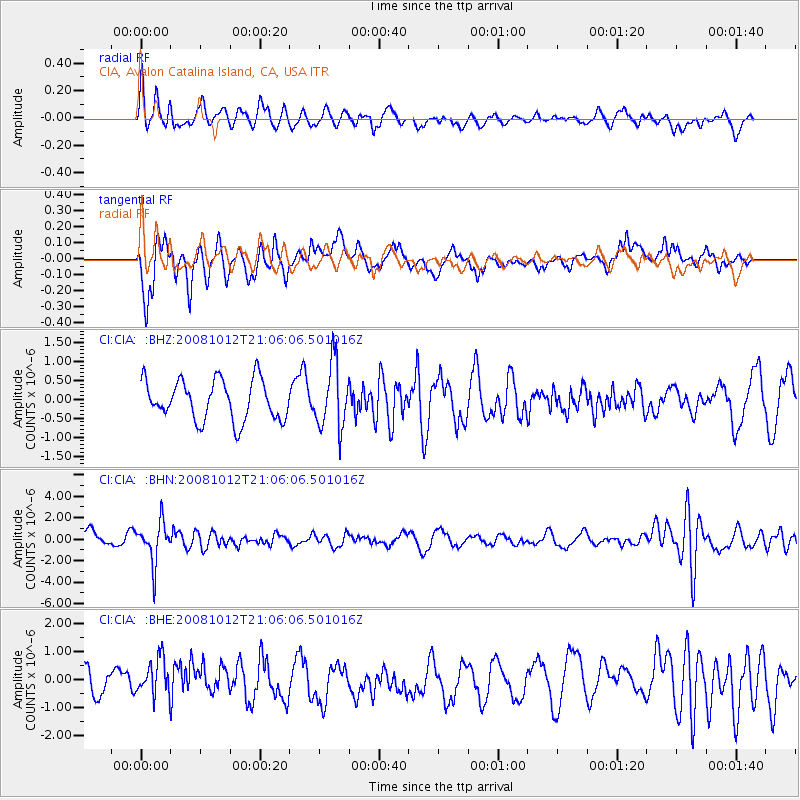
CIA CIA, Avalon Catalina Island, CA, USA - Earthquake Result Viewer
*The percent match for this event was below the threshold and hence no stack was calculated.
| Earthquake location: |
Southern Bolivia |
| Earthquake latitude/longitude: |
-20.1/-65.0 |
| Earthquake time(UTC): |
2008/10/12 (286) 20:55:41 GMT |
| Earthquake Depth: |
353 km |
| Earthquake Magnitude: |
6.0 MB, 6.2 MW, 6.2 MW |
| Earthquake Catalog/Contributor: |
WHDF/NEIC |
|
| Network: |
CI Caltech Regional Seismic Network |
| Station: |
CIA CIA, Avalon Catalina Island, CA, USA |
| Lat/Lon: |
33.40 N/118.41 W |
| Elevation: |
467 m |
|
| Distance: |
73.7 deg |
| Az: |
315.563 deg |
| Baz: |
128.143 deg |
| Ray Param: |
$rayparam |
*The percent match for this event was below the threshold and hence was not used in the summary stack. |
|
| Radial Match: |
63.73144 % |
| Radial Bump: |
400 |
| Transverse Match: |
80.83913 % |
| Transverse Bump: |
400 |
| SOD ConfigId: |
2560 |
| Insert Time: |
2010-02-25 21:00:29.769 +0000 |
| GWidth: |
2.5 |
| Max Bumps: |
400 |
| Tol: |
0.001 |
|
Signal To Noise
| Channel | StoN | STA | LTA |
| CI:CIA: :BHN:20081012T21:06:06.501016Z | 1.9354367 | 1.9056662E-6 | 9.846182E-7 |
| CI:CIA: :BHE:20081012T21:06:06.501016Z | 1.1046208 | 6.8214194E-7 | 6.175349E-7 |
| CI:CIA: :BHZ:20081012T21:06:06.501016Z | 1.6264075 | 8.5840634E-7 | 5.277929E-7 |
| Arrivals |
| Ps | |
| PpPs | |
| PsPs/PpSs | |


