You are here: Home > Network List > PR - Puerto Rico Seismic Network (PRSN) & Puerto Rico Strong Motion Program (PRSMP) Stations List
> Station MPR RUM > Earthquake Result Viewer
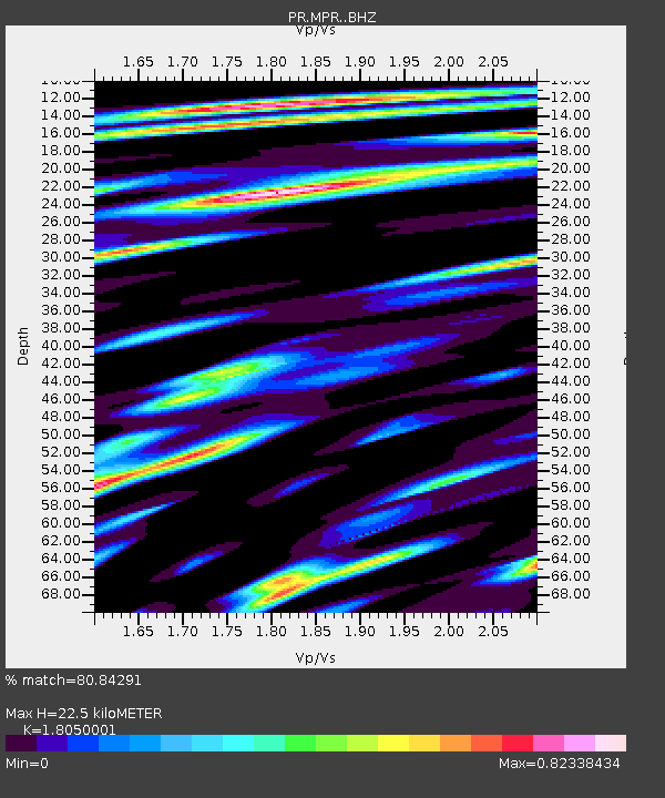
MPR RUM - Earthquake Result Viewer
| Earthquake location: |
Mendoza Province, Argentina |
| Earthquake latitude/longitude: |
-32.7/-67.1 |
| Earthquake time(UTC): |
2015/02/02 (033) 10:49:48 GMT |
| Earthquake Depth: |
172 km |
| Earthquake Magnitude: |
6.3 MO |
| Earthquake Catalog/Contributor: |
NEIC PDE/NEIC ALERT |
|
| Network: |
PR Puerto Rico Seismic Network (PRSN) & Puerto Rico Strong Motion Program (PRSMP) |
| Station: |
MPR RUM |
| Lat/Lon: |
18.21 N/67.14 W |
| Elevation: |
22 m |
|
| Distance: |
50.6 deg |
| Az: |
359.904 deg |
| Baz: |
179.915 deg |
| Ray Param: |
0.067325816 |
| Estimated Moho Depth: |
22.5 km |
| Estimated Crust Vp/Vs: |
1.81 |
| Assumed Crust Vp: |
5.14 km/s |
| Estimated Crust Vs: |
2.848 km/s |
| Estimated Crust Poisson's Ratio: |
0.28 |
|
| Radial Match: |
80.84291 % |
| Radial Bump: |
400 |
| Transverse Match: |
80.84293 % |
| Transverse Bump: |
400 |
| SOD ConfigId: |
6979251 |
| Insert Time: |
2019-04-16 11:27:37.436 +0000 |
| GWidth: |
2.5 |
| Max Bumps: |
400 |
| Tol: |
0.001 |
|

Signal To Noise
| Channel | StoN | STA | LTA |
| PR:MPR: :BHZ:20150202T10:57:58.795001Z | 9.030246 | 5.3388985E-6 | 5.91224E-7 |
| PR:MPR: :BHN:20150202T10:57:58.795001Z | 3.6551342 | 2.3736693E-6 | 6.4940684E-7 |
| $trig.getChannelId() | $trig.getValue() | $trig.getSTA() | $trig.getLTA() |
| Arrivals |
| Ps | 3.6 SECOND |
| PpPs | 12 SECOND |
| PsPs/PpSs | 16 SECOND |


