You are here: Home > Network List > TA - USArray Transportable Network (new EarthScope stations) Stations List
> Station 833A Chaparral WMA, Artesia Wells, TX, USA > Earthquake Result Viewer
833A Chaparral WMA, Artesia Wells, TX, USA - Earthquake Result Viewer

| Earthquake location: |
Mendoza Province, Argentina |
| Earthquake latitude/longitude: |
-32.7/-67.1 |
| Earthquake time(UTC): |
2015/02/02 (033) 10:49:48 GMT |
| Earthquake Depth: |
172 km |
| Earthquake Magnitude: |
6.3 MO |
| Earthquake Catalog/Contributor: |
NEIC PDE/NEIC ALERT |
|
| Network: |
TA USArray Transportable Network (new EarthScope stations) |
| Station: |
833A Chaparral WMA, Artesia Wells, TX, USA |
| Lat/Lon: |
28.32 N/99.39 W |
| Elevation: |
171 m |
|
| Distance: |
68.0 deg |
| Az: |
329.441 deg |
| Baz: |
150.911 deg |
| Ray Param: |
0.05608919 |
| Estimated Moho Depth: |
10.75 km |
| Estimated Crust Vp/Vs: |
1.63 |
| Assumed Crust Vp: |
6.347 km/s |
| Estimated Crust Vs: |
3.888 km/s |
| Estimated Crust Poisson's Ratio: |
0.20 |
|
| Radial Match: |
90.432594 % |
| Radial Bump: |
400 |
| Transverse Match: |
74.94512 % |
| Transverse Bump: |
400 |
| SOD ConfigId: |
6979251 |
| Insert Time: |
2019-04-16 11:28:39.323 +0000 |
| GWidth: |
2.5 |
| Max Bumps: |
400 |
| Tol: |
0.001 |
|
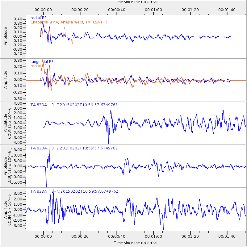
Signal To Noise
| Channel | StoN | STA | LTA |
| TA:833A: :BHZ:20150202T10:59:57.674976Z | 17.44883 | 6.4424385E-6 | 3.6921895E-7 |
| TA:833A: :BHN:20150202T10:59:57.674976Z | 4.760576 | 1.3572751E-6 | 2.8510735E-7 |
| TA:833A: :BHE:20150202T10:59:57.674976Z | 5.5045304 | 1.3144434E-6 | 2.38793E-7 |
| Arrivals |
| Ps | 1.1 SECOND |
| PpPs | 4.3 SECOND |
| PsPs/PpSs | 5.4 SECOND |


