You are here: Home > Network List > TA - USArray Transportable Network (new EarthScope stations) Stations List
> Station 121A Cookes Peak, Deming, NM, USA > Earthquake Result Viewer
121A Cookes Peak, Deming, NM, USA - Earthquake Result Viewer
| Earthquake location: |
Mendoza Province, Argentina |
| Earthquake latitude/longitude: |
-32.7/-67.1 |
| Earthquake time(UTC): |
2015/02/02 (033) 10:49:48 GMT |
| Earthquake Depth: |
172 km |
| Earthquake Magnitude: |
6.3 MO |
| Earthquake Catalog/Contributor: |
NEIC PDE/NEIC ALERT |
|
| Network: |
TA USArray Transportable Network (new EarthScope stations) |
| Station: |
121A Cookes Peak, Deming, NM, USA |
| Lat/Lon: |
32.53 N/107.79 W |
| Elevation: |
1652 m |
|
| Distance: |
75.4 deg |
| Az: |
325.288 deg |
| Baz: |
145.368 deg |
| Ray Param: |
0.051239423 |
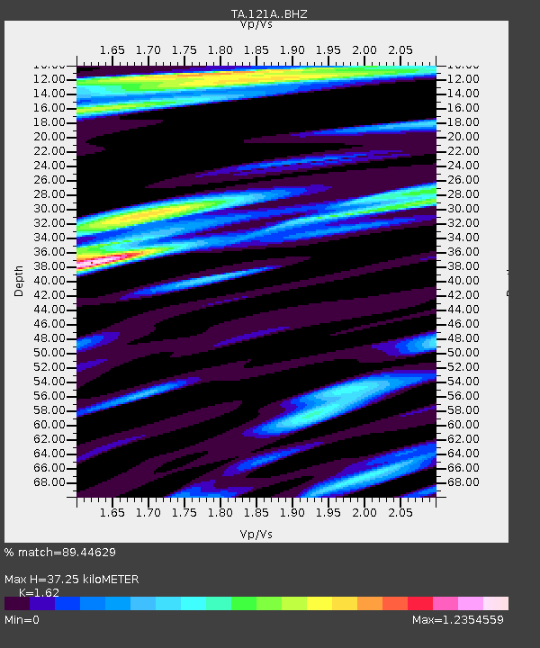
| Estimated Moho Depth: |
37.25 km |
| Estimated Crust Vp/Vs: |
1.62 |
| Assumed Crust Vp: |
6.502 km/s |
| Estimated Crust Vs: |
4.013 km/s |
| Estimated Crust Poisson's Ratio: |
0.19 |
|
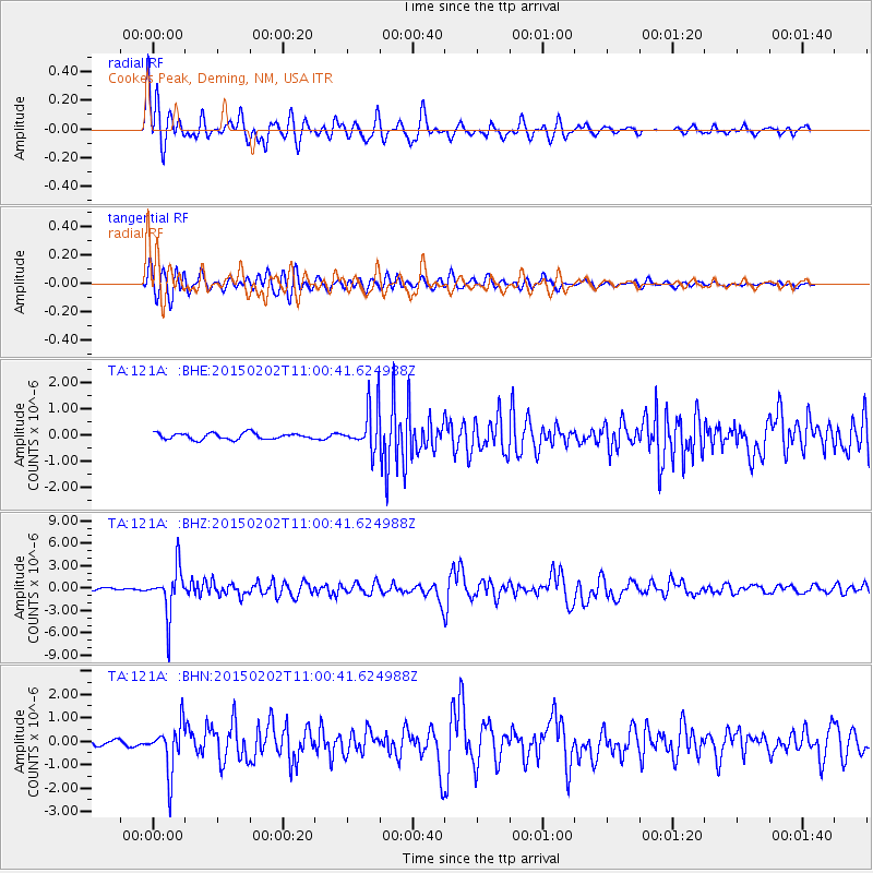
| Radial Match: |
89.44629 % |
| Radial Bump: |
400 |
| Transverse Match: |
75.458496 % |
| Transverse Bump: |
400 |
| SOD ConfigId: |
6979251 |
| Insert Time: |
2019-04-16 11:28:39.657 +0000 |
| GWidth: |
2.5 |
| Max Bumps: |
400 |
| Tol: |
0.001 |
|
Signal To Noise
| Channel | StoN | STA | LTA |
| TA:121A: :BHZ:20150202T11:00:41.624988Z | 19.036219 | 3.1372915E-6 | 1.6480645E-7 |
| TA:121A: :BHN:20150202T11:00:41.624988Z | 7.4848437 | 1.0242848E-6 | 1.3684786E-7 |
| TA:121A: :BHE:20150202T11:00:41.624988Z | 7.528336 | 8.804758E-7 | 1.16954894E-7 |
| Arrivals |
| Ps | 3.7 SECOND |
| PpPs | 14 SECOND |
| PsPs/PpSs | 18 SECOND |


