You are here: Home > Network List > TA - USArray Transportable Network (new EarthScope stations) Stations List
> Station A04D Lummi Island, WA, USA > Earthquake Result Viewer
A04D Lummi Island, WA, USA - Earthquake Result Viewer
| Earthquake location: |
Mendoza Province, Argentina |
| Earthquake latitude/longitude: |
-32.7/-67.1 |
| Earthquake time(UTC): |
2015/02/02 (033) 10:49:48 GMT |
| Earthquake Depth: |
172 km |
| Earthquake Magnitude: |
6.3 MO |
| Earthquake Catalog/Contributor: |
NEIC PDE/NEIC ALERT |
|
| Network: |
TA USArray Transportable Network (new EarthScope stations) |
| Station: |
A04D Lummi Island, WA, USA |
| Lat/Lon: |
48.72 N/122.71 W |
| Elevation: |
13 m |
|
| Distance: |
95.0 deg |
| Az: |
326.712 deg |
| Baz: |
135.68 deg |
| Ray Param: |
0.04075189 |
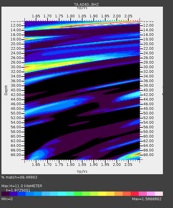
| Estimated Moho Depth: |
11.0 km |
| Estimated Crust Vp/Vs: |
1.97 |
| Assumed Crust Vp: |
6.566 km/s |
| Estimated Crust Vs: |
3.329 km/s |
| Estimated Crust Poisson's Ratio: |
0.33 |
|
| Radial Match: |
86.49983 % |
| Radial Bump: |
400 |
| Transverse Match: |
65.54991 % |
| Transverse Bump: |
400 |
| SOD ConfigId: |
6979251 |
| Insert Time: |
2019-04-16 11:28:43.299 +0000 |
| GWidth: |
2.5 |
| Max Bumps: |
400 |
| Tol: |
0.001 |
|
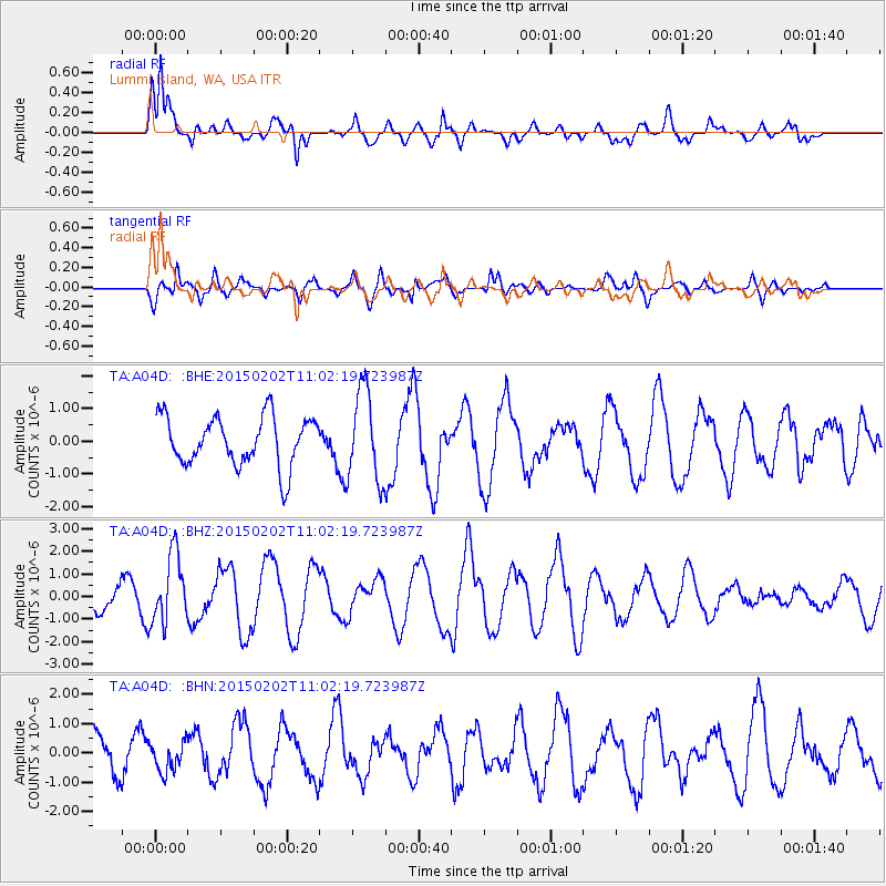
Signal To Noise
| Channel | StoN | STA | LTA |
| TA:A04D: :BHZ:20150202T11:02:19.723987Z | 3.1163986 | 1.5125868E-6 | 4.853637E-7 |
| TA:A04D: :BHN:20150202T11:02:19.723987Z | 0.6855745 | 5.0816044E-7 | 7.412184E-7 |
| TA:A04D: :BHE:20150202T11:02:19.723987Z | 1.9646388 | 1.4362022E-6 | 7.310261E-7 |
| Arrivals |
| Ps | 1.7 SECOND |
| PpPs | 4.9 SECOND |
| PsPs/PpSs | 6.5 SECOND |


