You are here: Home > Network List > TA - USArray Transportable Network (new EarthScope stations) Stations List
> Station C06D Leavenworth, WQ, USA > Earthquake Result Viewer
C06D Leavenworth, WQ, USA - Earthquake Result Viewer
| Earthquake location: |
Mendoza Province, Argentina |
| Earthquake latitude/longitude: |
-32.7/-67.1 |
| Earthquake time(UTC): |
2015/02/02 (033) 10:49:48 GMT |
| Earthquake Depth: |
172 km |
| Earthquake Magnitude: |
6.3 MO |
| Earthquake Catalog/Contributor: |
NEIC PDE/NEIC ALERT |
|
| Network: |
TA USArray Transportable Network (new EarthScope stations) |
| Station: |
C06D Leavenworth, WQ, USA |
| Lat/Lon: |
47.92 N/120.89 W |
| Elevation: |
544 m |
|
| Distance: |
93.6 deg |
| Az: |
327.038 deg |
| Baz: |
137.005 deg |
| Ray Param: |
0.04111195 |
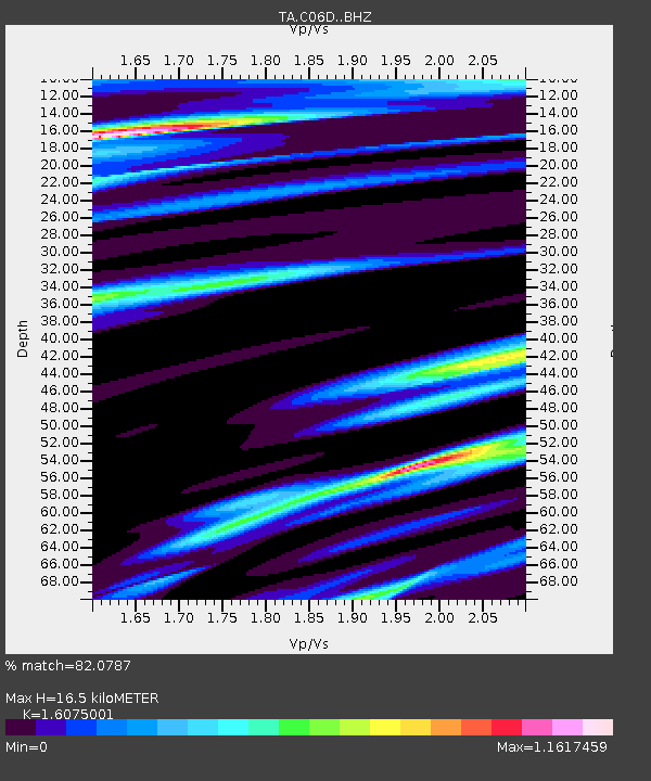
| Estimated Moho Depth: |
16.5 km |
| Estimated Crust Vp/Vs: |
1.61 |
| Assumed Crust Vp: |
6.597 km/s |
| Estimated Crust Vs: |
4.104 km/s |
| Estimated Crust Poisson's Ratio: |
0.18 |
|
| Radial Match: |
82.0787 % |
| Radial Bump: |
400 |
| Transverse Match: |
64.97519 % |
| Transverse Bump: |
400 |
| SOD ConfigId: |
6979251 |
| Insert Time: |
2019-04-16 11:28:55.023 +0000 |
| GWidth: |
2.5 |
| Max Bumps: |
400 |
| Tol: |
0.001 |
|
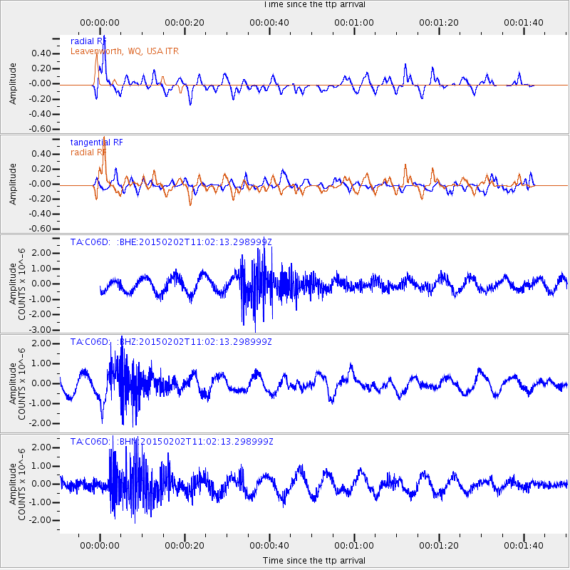
Signal To Noise
| Channel | StoN | STA | LTA |
| TA:C06D: :BHZ:20150202T11:02:13.298999Z | 1.8702728 | 9.022164E-7 | 4.823983E-7 |
| TA:C06D: :BHN:20150202T11:02:13.298999Z | 3.4343126 | 7.820024E-7 | 2.2770274E-7 |
| TA:C06D: :BHE:20150202T11:02:13.298999Z | 1.6730417 | 7.909166E-7 | 4.727417E-7 |
| Arrivals |
| Ps | 1.6 SECOND |
| PpPs | 6.4 SECOND |
| PsPs/PpSs | 7.9 SECOND |


