You are here: Home > Network List > TA - USArray Transportable Network (new EarthScope stations) Stations List
> Station R11A Troy Canyon, Currant, NV, USA > Earthquake Result Viewer
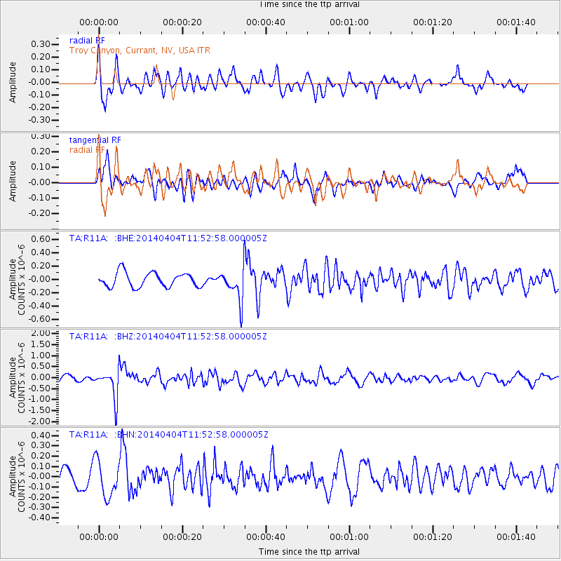
R11A Troy Canyon, Currant, NV, USA - Earthquake Result Viewer
*The percent match for this event was below the threshold and hence no stack was calculated.
| Earthquake location: |
Solomon Islands |
| Earthquake latitude/longitude: |
-10.5/161.7 |
| Earthquake time(UTC): |
2014/04/04 (094) 11:40:32 GMT |
| Earthquake Depth: |
64 km |
| Earthquake Magnitude: |
6.0 MB, 6.0 MWC, 6.0 MWW, 6.0 MWB |
| Earthquake Catalog/Contributor: |
NEIC PDE/NEIC COMCAT |
|
| Network: |
TA USArray Transportable Network (new EarthScope stations) |
| Station: |
R11A Troy Canyon, Currant, NV, USA |
| Lat/Lon: |
38.35 N/115.59 W |
| Elevation: |
1756 m |
|
| Distance: |
90.8 deg |
| Az: |
51.265 deg |
| Baz: |
257.318 deg |
| Ray Param: |
$rayparam |
*The percent match for this event was below the threshold and hence was not used in the summary stack. |
|
| Radial Match: |
74.67351 % |
| Radial Bump: |
400 |
| Transverse Match: |
65.01691 % |
| Transverse Bump: |
400 |
| SOD ConfigId: |
626651 |
| Insert Time: |
2014-04-22 10:31:59.802 +0000 |
| GWidth: |
2.5 |
| Max Bumps: |
400 |
| Tol: |
0.001 |
|
Signal To Noise
| Channel | StoN | STA | LTA |
| TA:R11A: :BHZ:20140404T11:52:58.000005Z | 5.02641 | 6.73036E-7 | 1.3389995E-7 |
| TA:R11A: :BHN:20140404T11:52:58.000005Z | 2.8222744 | 1.7887652E-7 | 6.338027E-8 |
| TA:R11A: :BHE:20140404T11:52:58.000005Z | 2.2843368 | 2.481844E-7 | 1.0864615E-7 |
| Arrivals |
| Ps | |
| PpPs | |
| PsPs/PpSs | |


