You are here: Home > Network List > UW - Pacific Northwest Regional Seismic Network Stations List
> Station MRBL Marblemount, WA, USA > Earthquake Result Viewer
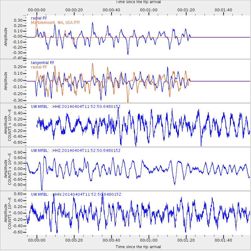
MRBL Marblemount, WA, USA - Earthquake Result Viewer
*The percent match for this event was below the threshold and hence no stack was calculated.
| Earthquake location: |
Solomon Islands |
| Earthquake latitude/longitude: |
-10.5/161.7 |
| Earthquake time(UTC): |
2014/04/04 (094) 11:40:32 GMT |
| Earthquake Depth: |
64 km |
| Earthquake Magnitude: |
6.0 MB, 6.0 MWC, 6.0 MWW, 6.0 MWB |
| Earthquake Catalog/Contributor: |
NEIC PDE/NEIC COMCAT |
|
| Network: |
UW Pacific Northwest Regional Seismic Network |
| Station: |
MRBL Marblemount, WA, USA |
| Lat/Lon: |
48.52 N/121.48 W |
| Elevation: |
75 m |
|
| Distance: |
89.2 deg |
| Az: |
40.352 deg |
| Baz: |
253.266 deg |
| Ray Param: |
$rayparam |
*The percent match for this event was below the threshold and hence was not used in the summary stack. |
|
| Radial Match: |
61.997814 % |
| Radial Bump: |
347 |
| Transverse Match: |
56.43764 % |
| Transverse Bump: |
400 |
| SOD ConfigId: |
626651 |
| Insert Time: |
2014-04-22 10:34:59.835 +0000 |
| GWidth: |
2.5 |
| Max Bumps: |
400 |
| Tol: |
0.001 |
|
Signal To Noise
| Channel | StoN | STA | LTA |
| UW:MRBL: :HHZ:20140404T11:52:50.648015Z | 4.0625677 | 5.14168E-7 | 1.2656233E-7 |
| UW:MRBL: :HHN:20140404T11:52:50.648015Z | 0.9490559 | 1.4642296E-7 | 1.5428276E-7 |
| UW:MRBL: :HHE:20140404T11:52:50.648015Z | 1.0414695 | 1.7414943E-7 | 1.6721512E-7 |
| Arrivals |
| Ps | |
| PpPs | |
| PsPs/PpSs | |


