You are here: Home > Network List > II - Global Seismograph Network (GSN - IRIS/IDA) Stations List
> Station DGAR Diego Garcia, Chagos Islands, Indian Ocean > Earthquake Result Viewer
DGAR Diego Garcia, Chagos Islands, Indian Ocean - Earthquake Result Viewer

| Earthquake location: |
Volcano Islands, Japan Region |
| Earthquake latitude/longitude: |
22.0/142.7 |
| Earthquake time(UTC): |
2007/09/28 (271) 13:38:59 GMT |
| Earthquake Depth: |
276 km |
| Earthquake Magnitude: |
6.7 MB, 7.4 MW, 7.4 MW |
| Earthquake Catalog/Contributor: |
WHDF/NEIC |
|
| Network: |
II Global Seismograph Network (GSN - IRIS/IDA) |
| Station: |
DGAR Diego Garcia, Chagos Islands, Indian Ocean |
| Lat/Lon: |
7.41 S/72.45 E |
| Elevation: |
1.0 m |
|
| Distance: |
74.7 deg |
| Az: |
255.341 deg |
| Baz: |
64.862 deg |
| Ray Param: |
0.051403053 |
| Estimated Moho Depth: |
22.5 km |
| Estimated Crust Vp/Vs: |
2.10 |
| Assumed Crust Vp: |
5.265 km/s |
| Estimated Crust Vs: |
2.51 km/s |
| Estimated Crust Poisson's Ratio: |
0.35 |
|
| Radial Match: |
84.8932 % |
| Radial Bump: |
400 |
| Transverse Match: |
76.18432 % |
| Transverse Bump: |
400 |
| SOD ConfigId: |
2564 |
| Insert Time: |
2010-03-01 20:21:56.056 +0000 |
| GWidth: |
2.5 |
| Max Bumps: |
400 |
| Tol: |
0.001 |
|
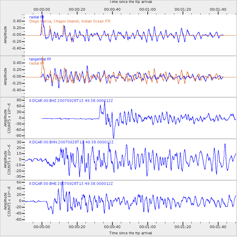
Signal To Noise
| Channel | StoN | STA | LTA |
| II:DGAR:00:BHN:20070928T13:49:38.000012Z | 2.6096435 | 4.0095592E-6 | 1.5364395E-6 |
| II:DGAR:00:BHE:20070928T13:49:38.000012Z | 5.650349 | 1.1473008E-5 | 2.0304954E-6 |
| II:DGAR:00:BHZ:20070928T13:49:38.000012Z | 22.331717 | 2.5547059E-5 | 1.143981E-6 |
| Arrivals |
| Ps | 4.8 SECOND |
| PpPs | 13 SECOND |
| PsPs/PpSs | 18 SECOND |


