You are here: Home > Network List > II - Global Seismograph Network (GSN - IRIS/IDA) Stations List
> Station DGAR Diego Garcia, Chagos Islands, Indian Ocean > Earthquake Result Viewer
DGAR Diego Garcia, Chagos Islands, Indian Ocean - Earthquake Result Viewer

| Earthquake location: |
South Sandwich Islands Region |
| Earthquake latitude/longitude: |
-57.3/-23.4 |
| Earthquake time(UTC): |
2008/02/23 (054) 15:57:19 GMT |
| Earthquake Depth: |
10 km |
| Earthquake Magnitude: |
6.2 MB, 6.7 MS, 6.7 MW, 6.7 MW |
| Earthquake Catalog/Contributor: |
WHDF/NEIC |
|
| Network: |
II Global Seismograph Network (GSN - IRIS/IDA) |
| Station: |
DGAR Diego Garcia, Chagos Islands, Indian Ocean |
| Lat/Lon: |
7.41 S/72.45 E |
| Elevation: |
1.0 m |
|
| Distance: |
87.0 deg |
| Az: |
98.916 deg |
| Baz: |
212.706 deg |
| Ray Param: |
0.043652963 |
| Estimated Moho Depth: |
10.0 km |
| Estimated Crust Vp/Vs: |
1.60 |
| Assumed Crust Vp: |
5.265 km/s |
| Estimated Crust Vs: |
3.291 km/s |
| Estimated Crust Poisson's Ratio: |
0.18 |
|
| Radial Match: |
99.994415 % |
| Radial Bump: |
2 |
| Transverse Match: |
99.934 % |
| Transverse Bump: |
10 |
| SOD ConfigId: |
2564 |
| Insert Time: |
2010-03-01 20:22:04.394 +0000 |
| GWidth: |
2.5 |
| Max Bumps: |
400 |
| Tol: |
0.001 |
|
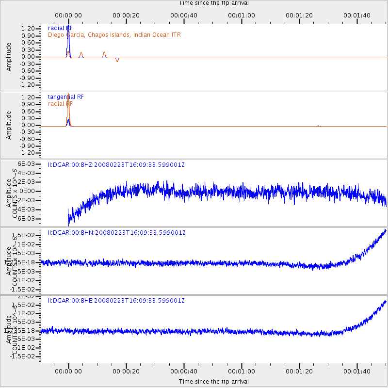
Signal To Noise
| Channel | StoN | STA | LTA |
| II:DGAR:00:BHN:20080223T16:09:33.599001Z | 1.0134149 | 1.7157482E-9 | 1.6930364E-9 |
| II:DGAR:00:BHE:20080223T16:09:33.599001Z | 0.89730144 | 1.4963998E-9 | 1.6676668E-9 |
| II:DGAR:00:BHZ:20080223T16:09:33.599001Z | 1.0391055 | 2.2150621E-9 | 2.1317008E-9 |
| Arrivals |
| Ps | 1.2 SECOND |
| PpPs | 4.9 SECOND |
| PsPs/PpSs | 6.0 SECOND |


