You are here: Home > Network List > TA - USArray Transportable Network (new EarthScope stations) Stations List
> Station O48A Farmland, IN, USA > Earthquake Result Viewer
O48A Farmland, IN, USA - Earthquake Result Viewer

| Earthquake location: |
Mendoza Province, Argentina |
| Earthquake latitude/longitude: |
-32.7/-67.1 |
| Earthquake time(UTC): |
2015/02/02 (033) 10:49:48 GMT |
| Earthquake Depth: |
172 km |
| Earthquake Magnitude: |
6.3 MO |
| Earthquake Catalog/Contributor: |
NEIC PDE/NEIC ALERT |
|
| Network: |
TA USArray Transportable Network (new EarthScope stations) |
| Station: |
O48A Farmland, IN, USA |
| Lat/Lon: |
40.26 N/85.16 W |
| Elevation: |
300 m |
|
| Distance: |
74.5 deg |
| Az: |
345.722 deg |
| Baz: |
164.236 deg |
| Ray Param: |
0.05184018 |
| Estimated Moho Depth: |
35.25 km |
| Estimated Crust Vp/Vs: |
2.04 |
| Assumed Crust Vp: |
6.498 km/s |
| Estimated Crust Vs: |
3.181 km/s |
| Estimated Crust Poisson's Ratio: |
0.34 |
|
| Radial Match: |
80.828835 % |
| Radial Bump: |
400 |
| Transverse Match: |
56.081757 % |
| Transverse Bump: |
400 |
| SOD ConfigId: |
6980671 |
| Insert Time: |
2019-04-16 11:38:59.430 +0000 |
| GWidth: |
2.5 |
| Max Bumps: |
400 |
| Tol: |
0.001 |
|
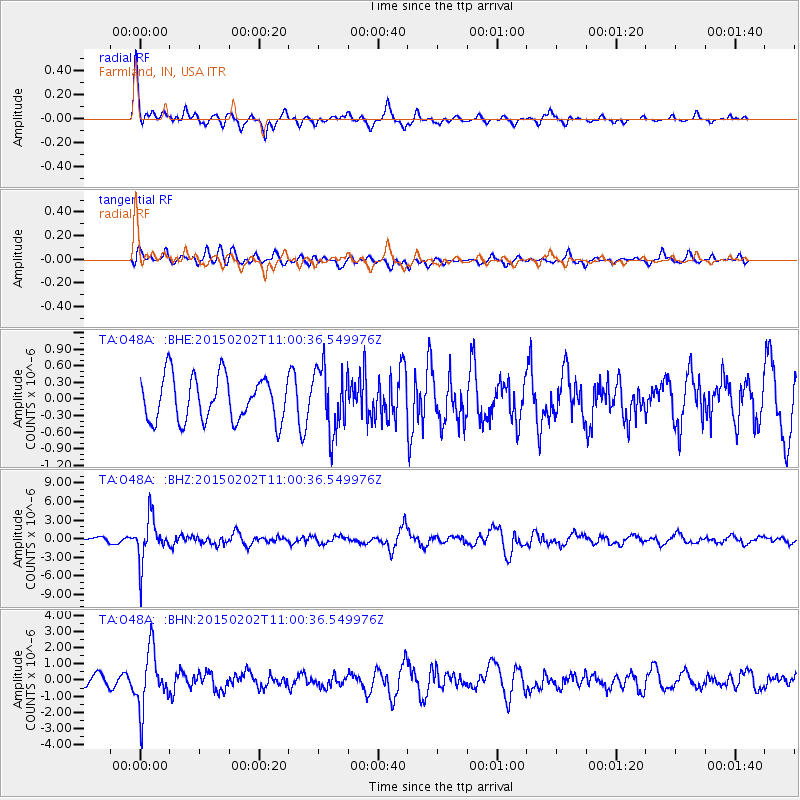
Signal To Noise
| Channel | StoN | STA | LTA |
| TA:O48A: :BHZ:20150202T11:00:36.549976Z | 7.517853 | 3.4311527E-6 | 4.564006E-7 |
| TA:O48A: :BHN:20150202T11:00:36.549976Z | 5.3161736 | 1.790861E-6 | 3.368703E-7 |
| TA:O48A: :BHE:20150202T11:00:36.549976Z | 1.362052 | 5.593825E-7 | 4.10691E-7 |
| Arrivals |
| Ps | 5.8 SECOND |
| PpPs | 16 SECOND |
| PsPs/PpSs | 22 SECOND |


