You are here: Home > Network List > TA - USArray Transportable Network (new EarthScope stations) Stations List
> Station R11A Troy Canyon, Currant, NV, USA > Earthquake Result Viewer
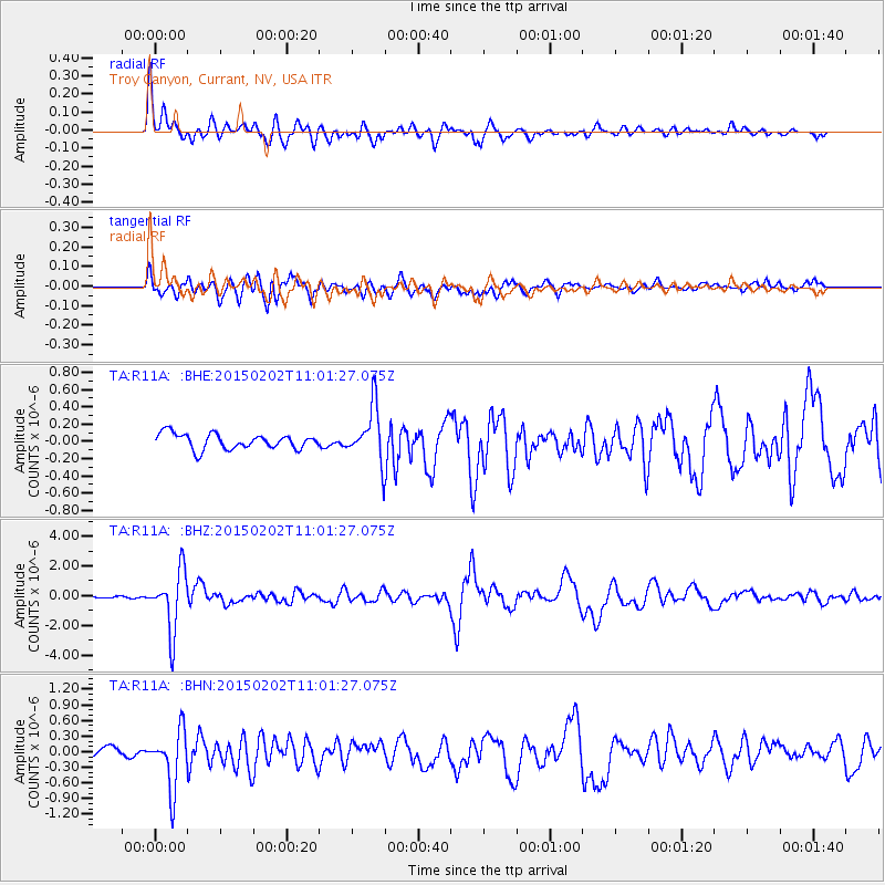
R11A Troy Canyon, Currant, NV, USA - Earthquake Result Viewer
*The percent match for this event was below the threshold and hence no stack was calculated.
| Earthquake location: |
Mendoza Province, Argentina |
| Earthquake latitude/longitude: |
-32.7/-67.1 |
| Earthquake time(UTC): |
2015/02/02 (033) 10:49:48 GMT |
| Earthquake Depth: |
172 km |
| Earthquake Magnitude: |
6.3 MO |
| Earthquake Catalog/Contributor: |
NEIC PDE/NEIC ALERT |
|
| Network: |
TA USArray Transportable Network (new EarthScope stations) |
| Station: |
R11A Troy Canyon, Currant, NV, USA |
| Lat/Lon: |
38.35 N/115.59 W |
| Elevation: |
1756 m |
|
| Distance: |
83.9 deg |
| Az: |
323.667 deg |
| Baz: |
140.562 deg |
| Ray Param: |
$rayparam |
*The percent match for this event was below the threshold and hence was not used in the summary stack. |
|
| Radial Match: |
73.08631 % |
| Radial Bump: |
400 |
| Transverse Match: |
76.13046 % |
| Transverse Bump: |
400 |
| SOD ConfigId: |
6980671 |
| Insert Time: |
2019-04-16 11:39:54.609 +0000 |
| GWidth: |
2.5 |
| Max Bumps: |
400 |
| Tol: |
0.001 |
|
Signal To Noise
| Channel | StoN | STA | LTA |
| TA:R11A: :BHZ:20150202T11:01:27.075Z | 19.971577 | 2.0180767E-6 | 1.0104744E-7 |
| TA:R11A: :BHN:20150202T11:01:27.075Z | 7.1459007 | 5.640424E-7 | 7.89323E-8 |
| TA:R11A: :BHE:20150202T11:01:27.075Z | 3.8489673 | 3.382339E-7 | 8.787653E-8 |
| Arrivals |
| Ps | |
| PpPs | |
| PsPs/PpSs | |


