You are here: Home > Network List > TA - USArray Transportable Network (new EarthScope stations) Stations List
> Station X43A Marvell, AR, USA > Earthquake Result Viewer
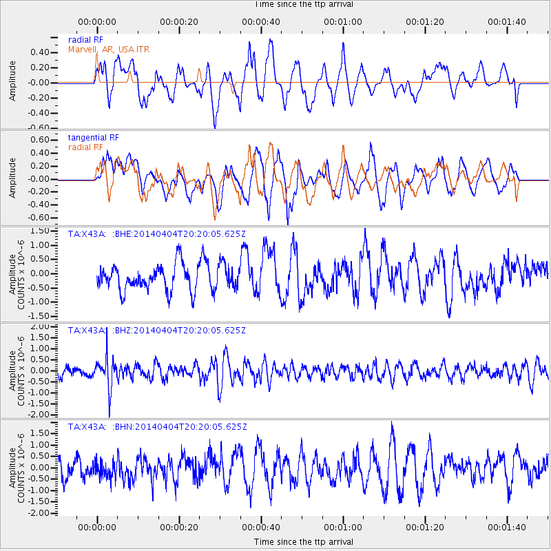
X43A Marvell, AR, USA - Earthquake Result Viewer
*The percent match for this event was below the threshold and hence no stack was calculated.
| Earthquake location: |
Southern Greece |
| Earthquake latitude/longitude: |
37.2/23.8 |
| Earthquake time(UTC): |
2014/04/04 (094) 20:08:07 GMT |
| Earthquake Depth: |
107 km |
| Earthquake Magnitude: |
5.5 MWB, 5.5 MWR, 5.6 MWC, 5.6 MWW |
| Earthquake Catalog/Contributor: |
NEIC PDE/NEIC COMCAT |
|
| Network: |
TA USArray Transportable Network (new EarthScope stations) |
| Station: |
X43A Marvell, AR, USA |
| Lat/Lon: |
34.52 N/90.88 W |
| Elevation: |
53 m |
|
| Distance: |
86.3 deg |
| Az: |
311.231 deg |
| Baz: |
46.629 deg |
| Ray Param: |
$rayparam |
*The percent match for this event was below the threshold and hence was not used in the summary stack. |
|
| Radial Match: |
52.961723 % |
| Radial Bump: |
400 |
| Transverse Match: |
65.42241 % |
| Transverse Bump: |
400 |
| SOD ConfigId: |
626651 |
| Insert Time: |
2014-04-22 11:02:39.445 +0000 |
| GWidth: |
2.5 |
| Max Bumps: |
400 |
| Tol: |
0.001 |
|
Signal To Noise
| Channel | StoN | STA | LTA |
| TA:X43A: :BHZ:20140404T20:20:05.625Z | 3.4008248 | 6.9019273E-7 | 2.0294863E-7 |
| TA:X43A: :BHN:20140404T20:20:05.625Z | 0.9219702 | 3.3992373E-7 | 3.6869275E-7 |
| TA:X43A: :BHE:20140404T20:20:05.625Z | 0.9567967 | 4.2588897E-7 | 4.451196E-7 |
| Arrivals |
| Ps | |
| PpPs | |
| PsPs/PpSs | |


