You are here: Home > Network List > II - Global Seismograph Network (GSN - IRIS/IDA) Stations List
> Station DGAR Diego Garcia, Chagos Islands, Indian Ocean > Earthquake Result Viewer
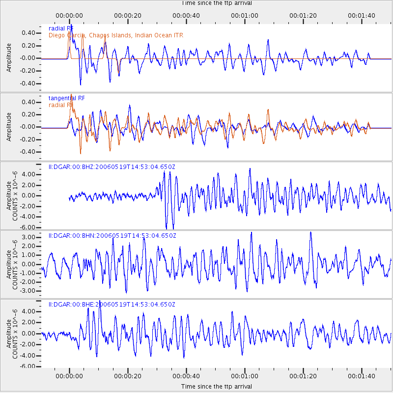
DGAR Diego Garcia, Chagos Islands, Indian Ocean - Earthquake Result Viewer

| Earthquake location: |
Southern Molucca Sea |
| Earthquake latitude/longitude: |
-0.1/124.7 |
| Earthquake time(UTC): |
2006/05/19 (139) 14:44:24 GMT |
| Earthquake Depth: |
35 km |
| Earthquake Magnitude: |
6.0 MB, 5.6 MS, 6.2 MW, 6.1 MW |
| Earthquake Catalog/Contributor: |
WHDF/NEIC |
|
| Network: |
II Global Seismograph Network (GSN - IRIS/IDA) |
| Station: |
DGAR Diego Garcia, Chagos Islands, Indian Ocean |
| Lat/Lon: |
7.41 S/72.45 E |
| Elevation: |
1.0 m |
|
| Distance: |
52.6 deg |
| Az: |
260.827 deg |
| Baz: |
84.512 deg |
| Ray Param: |
0.06658817 |
| Estimated Moho Depth: |
21.75 km |
| Estimated Crust Vp/Vs: |
2.10 |
| Assumed Crust Vp: |
5.265 km/s |
| Estimated Crust Vs: |
2.51 km/s |
| Estimated Crust Poisson's Ratio: |
0.35 |
|
| Radial Match: |
81.30858 % |
| Radial Bump: |
400 |
| Transverse Match: |
68.74912 % |
| Transverse Bump: |
400 |
| SOD ConfigId: |
2669 |
| Insert Time: |
2010-03-01 20:22:22.789 +0000 |
| GWidth: |
2.5 |
| Max Bumps: |
400 |
| Tol: |
0.001 |
|
Signal To Noise
| Channel | StoN | STA | LTA |
| II:DGAR:00:BHN:20060519T14:53:04.650Z | 1.2567967 | 8.746412E-7 | 6.959289E-7 |
| II:DGAR:00:BHE:20060519T14:53:04.650Z | 2.362559 | 1.0538319E-6 | 4.4605522E-7 |
| II:DGAR:00:BHZ:20060519T14:53:04.650Z | 6.6264954 | 2.8480051E-6 | 4.2979056E-7 |
| Arrivals |
| Ps | 4.7 SECOND |
| PpPs | 12 SECOND |
| PsPs/PpSs | 17 SECOND |


