You are here: Home > Network List > II - Global Seismograph Network (GSN - IRIS/IDA) Stations List
> Station DGAR Diego Garcia, Chagos Islands, Indian Ocean > Earthquake Result Viewer
DGAR Diego Garcia, Chagos Islands, Indian Ocean - Earthquake Result Viewer

| Earthquake location: |
Seram, Indonesia |
| Earthquake latitude/longitude: |
-3.6/127.2 |
| Earthquake time(UTC): |
2006/03/14 (073) 06:57:33 GMT |
| Earthquake Depth: |
30 km |
| Earthquake Magnitude: |
6.4 MB, 6.7 MS, 6.7 MW, 6.7 MW |
| Earthquake Catalog/Contributor: |
WHDF/NEIC |
|
| Network: |
II Global Seismograph Network (GSN - IRIS/IDA) |
| Station: |
DGAR Diego Garcia, Chagos Islands, Indian Ocean |
| Lat/Lon: |
7.41 S/72.45 E |
| Elevation: |
1.0 m |
|
| Distance: |
54.6 deg |
| Az: |
263.502 deg |
| Baz: |
89.155 deg |
| Ray Param: |
0.065288745 |
| Estimated Moho Depth: |
55.75 km |
| Estimated Crust Vp/Vs: |
1.69 |
| Assumed Crust Vp: |
5.265 km/s |
| Estimated Crust Vs: |
3.125 km/s |
| Estimated Crust Poisson's Ratio: |
0.23 |
|
| Radial Match: |
89.45373 % |
| Radial Bump: |
400 |
| Transverse Match: |
83.58361 % |
| Transverse Bump: |
400 |
| SOD ConfigId: |
2422 |
| Insert Time: |
2010-03-01 20:22:25.274 +0000 |
| GWidth: |
2.5 |
| Max Bumps: |
400 |
| Tol: |
0.001 |
|
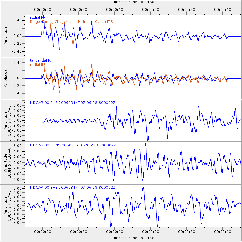
Signal To Noise
| Channel | StoN | STA | LTA |
| II:DGAR:00:BHN:20060314T07:06:28.800002Z | 0.93094176 | 6.926248E-7 | 7.440044E-7 |
| II:DGAR:00:BHE:20060314T07:06:28.800002Z | 2.5622742 | 2.1558633E-6 | 8.413866E-7 |
| II:DGAR:00:BHZ:20060314T07:06:28.800002Z | 3.454429 | 2.1708904E-6 | 6.2843685E-7 |
| Arrivals |
| Ps | 7.5 SECOND |
| PpPs | 27 SECOND |
| PsPs/PpSs | 35 SECOND |


