You are here: Home > Network List > US - United States National Seismic Network Stations List
> Station LAO LASA Array, Montana, USA > Earthquake Result Viewer
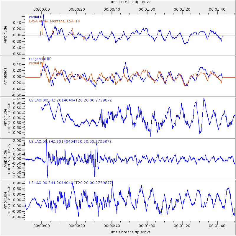
LAO LASA Array, Montana, USA - Earthquake Result Viewer
*The percent match for this event was below the threshold and hence no stack was calculated.
| Earthquake location: |
Southern Greece |
| Earthquake latitude/longitude: |
37.2/23.8 |
| Earthquake time(UTC): |
2014/04/04 (094) 20:08:07 GMT |
| Earthquake Depth: |
107 km |
| Earthquake Magnitude: |
5.5 MWB, 5.5 MWR, 5.6 MWC, 5.6 MWW |
| Earthquake Catalog/Contributor: |
NEIC PDE/NEIC COMCAT |
|
| Network: |
US United States National Seismic Network |
| Station: |
LAO LASA Array, Montana, USA |
| Lat/Lon: |
46.69 N/106.22 W |
| Elevation: |
902 m |
|
| Distance: |
85.2 deg |
| Az: |
328.044 deg |
| Baz: |
37.853 deg |
| Ray Param: |
$rayparam |
*The percent match for this event was below the threshold and hence was not used in the summary stack. |
|
| Radial Match: |
47.18069 % |
| Radial Bump: |
400 |
| Transverse Match: |
39.68745 % |
| Transverse Bump: |
400 |
| SOD ConfigId: |
626651 |
| Insert Time: |
2014-04-22 11:04:51.288 +0000 |
| GWidth: |
2.5 |
| Max Bumps: |
400 |
| Tol: |
0.001 |
|
Signal To Noise
| Channel | StoN | STA | LTA |
| US:LAO:00:BHZ:20140404T20:20:00.273987Z | 3.8834338 | 6.5884086E-7 | 1.696542E-7 |
| US:LAO:00:BH1:20140404T20:20:00.273987Z | 0.7563052 | 2.9170218E-7 | 3.856937E-7 |
| US:LAO:00:BH2:20140404T20:20:00.273987Z | 0.9000913 | 4.0931621E-7 | 4.5474965E-7 |
| Arrivals |
| Ps | |
| PpPs | |
| PsPs/PpSs | |


