You are here: Home > Network List > TA - USArray Transportable Network (new EarthScope stations) Stations List
> Station TPFO Pinon Flats, CA, USA > Earthquake Result Viewer
TPFO Pinon Flats, CA, USA - Earthquake Result Viewer
| Earthquake location: |
Mendoza Province, Argentina |
| Earthquake latitude/longitude: |
-32.7/-67.1 |
| Earthquake time(UTC): |
2015/02/02 (033) 10:49:48 GMT |
| Earthquake Depth: |
172 km |
| Earthquake Magnitude: |
6.3 MO |
| Earthquake Catalog/Contributor: |
NEIC PDE/NEIC ALERT |
|
| Network: |
TA USArray Transportable Network (new EarthScope stations) |
| Station: |
TPFO Pinon Flats, CA, USA |
| Lat/Lon: |
33.61 N/116.45 W |
| Elevation: |
1275 m |
|
| Distance: |
80.7 deg |
| Az: |
320.056 deg |
| Baz: |
139.569 deg |
| Ray Param: |
0.04768059 |
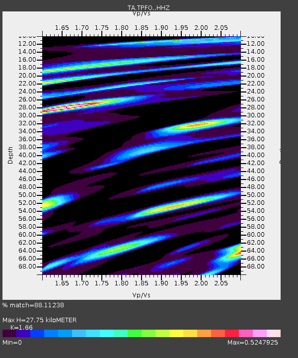
| Estimated Moho Depth: |
27.75 km |
| Estimated Crust Vp/Vs: |
1.66 |
| Assumed Crust Vp: |
6.264 km/s |
| Estimated Crust Vs: |
3.773 km/s |
| Estimated Crust Poisson's Ratio: |
0.22 |
|
| Radial Match: |
88.11238 % |
| Radial Bump: |
400 |
| Transverse Match: |
86.540886 % |
| Transverse Bump: |
400 |
| SOD ConfigId: |
6980671 |
| Insert Time: |
2019-04-16 11:40:45.422 +0000 |
| GWidth: |
2.5 |
| Max Bumps: |
400 |
| Tol: |
0.001 |
|
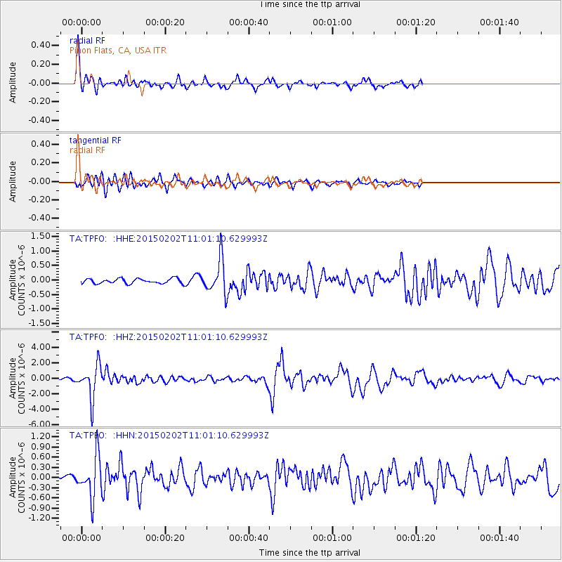
Signal To Noise
| Channel | StoN | STA | LTA |
| TA:TPFO: :HHZ:20150202T11:01:10.629993Z | 16.920265 | 2.2246609E-6 | 1.3147907E-7 |
| TA:TPFO: :HHN:20150202T11:01:10.629993Z | 9.624511 | 6.275554E-7 | 6.520387E-8 |
| TA:TPFO: :HHE:20150202T11:01:10.629993Z | 7.244701 | 6.2889035E-7 | 8.680694E-8 |
| Arrivals |
| Ps | 3.0 SECOND |
| PpPs | 11 SECOND |
| PsPs/PpSs | 14 SECOND |


