You are here: Home > Network List > AG - Arkansas Seismic Network Stations List
> Station HHAR Hobbs,AR > Earthquake Result Viewer
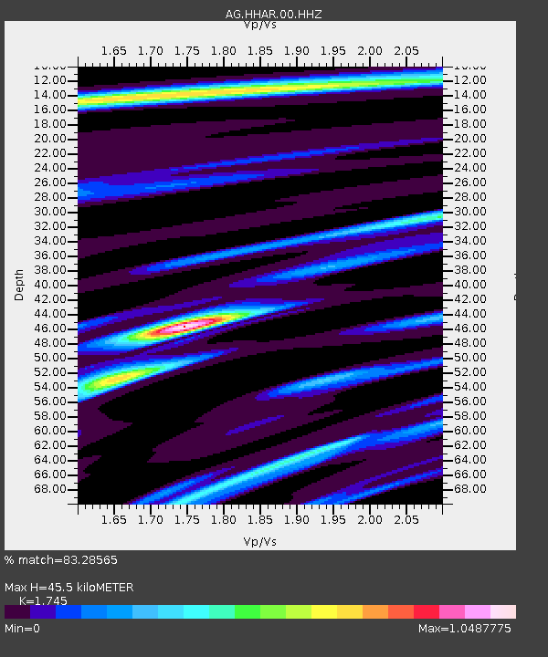
HHAR Hobbs,AR - Earthquake Result Viewer
| Earthquake location: |
Near Coast Of Northern Chile |
| Earthquake latitude/longitude: |
-20.2/-70.9 |
| Earthquake time(UTC): |
2014/04/07 (097) 13:43:20 GMT |
| Earthquake Depth: |
7.9 km |
| Earthquake Magnitude: |
5.8 MWB, 5.7 MWW, 5.7 MWC |
| Earthquake Catalog/Contributor: |
NEIC PDE/NEIC COMCAT |
|
| Network: |
AG Arkansas Seismic Network |
| Station: |
HHAR Hobbs,AR |
| Lat/Lon: |
36.28 N/93.94 W |
| Elevation: |
421 m |
|
| Distance: |
60.2 deg |
| Az: |
338.604 deg |
| Baz: |
154.901 deg |
| Ray Param: |
0.061676998 |
| Estimated Moho Depth: |
45.5 km |
| Estimated Crust Vp/Vs: |
1.75 |
| Assumed Crust Vp: |
6.53 km/s |
| Estimated Crust Vs: |
3.742 km/s |
| Estimated Crust Poisson's Ratio: |
0.26 |
|
| Radial Match: |
83.28565 % |
| Radial Bump: |
269 |
| Transverse Match: |
70.713875 % |
| Transverse Bump: |
387 |
| SOD ConfigId: |
626651 |
| Insert Time: |
2014-04-22 11:09:18.480 +0000 |
| GWidth: |
2.5 |
| Max Bumps: |
400 |
| Tol: |
0.001 |
|

Signal To Noise
| Channel | StoN | STA | LTA |
| AG:HHAR:00:HHZ:20140407T13:52:58.269983Z | 6.709378 | 6.642752E-7 | 9.900697E-8 |
| AG:HHAR:00:HHN:20140407T13:52:58.269983Z | 3.0410619 | 2.5590663E-7 | 8.415042E-8 |
| AG:HHAR:00:HHE:20140407T13:52:58.269983Z | 2.4527085 | 1.9441688E-7 | 7.926621E-8 |
| Arrivals |
| Ps | 5.5 SECOND |
| PpPs | 18 SECOND |
| PsPs/PpSs | 24 SECOND |


