You are here: Home > Network List > TA - USArray Transportable Network (new EarthScope stations) Stations List
> Station W56A Indian Trail, NC, USA > Earthquake Result Viewer
W56A Indian Trail, NC, USA - Earthquake Result Viewer
*The percent match for this event was below the threshold and hence no stack was calculated.
| Earthquake location: |
Mendoza Province, Argentina |
| Earthquake latitude/longitude: |
-32.7/-67.1 |
| Earthquake time(UTC): |
2015/02/02 (033) 10:49:48 GMT |
| Earthquake Depth: |
172 km |
| Earthquake Magnitude: |
6.3 MO |
| Earthquake Catalog/Contributor: |
NEIC PDE/NEIC ALERT |
|
| Network: |
TA USArray Transportable Network (new EarthScope stations) |
| Station: |
W56A Indian Trail, NC, USA |
| Lat/Lon: |
35.13 N/80.58 W |
| Elevation: |
177 m |
|
| Distance: |
68.7 deg |
| Az: |
348.129 deg |
| Baz: |
167.785 deg |
| Ray Param: |
$rayparam |
*The percent match for this event was below the threshold and hence was not used in the summary stack. |
|
| Radial Match: |
53.814705 % |
| Radial Bump: |
400 |
| Transverse Match: |
47.920162 % |
| Transverse Bump: |
400 |
| SOD ConfigId: |
6980671 |
| Insert Time: |
2019-04-16 11:41:26.733 +0000 |
| GWidth: |
2.5 |
| Max Bumps: |
400 |
| Tol: |
0.001 |
|
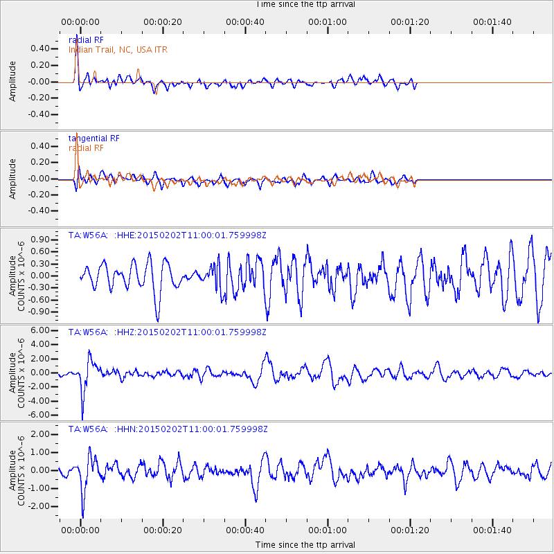
Signal To Noise
| Channel | StoN | STA | LTA |
| TA:W56A: :HHZ:20150202T11:00:01.759998Z | 5.0414715 | 2.243787E-6 | 4.450659E-7 |
| TA:W56A: :HHN:20150202T11:00:01.759998Z | 3.9143546 | 9.557892E-7 | 2.4417545E-7 |
| TA:W56A: :HHE:20150202T11:00:01.759998Z | 1.0620358 | 3.50022E-7 | 3.2957647E-7 |
| Arrivals |
| Ps | |
| PpPs | |
| PsPs/PpSs | |


