You are here: Home > Network List > TA - USArray Transportable Network (new EarthScope stations) Stations List
> Station W41B Gary Mavity, Velonia, AR, USA > Earthquake Result Viewer
W41B Gary Mavity, Velonia, AR, USA - Earthquake Result Viewer
| Earthquake location: |
Mendoza Province, Argentina |
| Earthquake latitude/longitude: |
-32.7/-67.1 |
| Earthquake time(UTC): |
2015/02/02 (033) 10:49:48 GMT |
| Earthquake Depth: |
172 km |
| Earthquake Magnitude: |
6.3 MO |
| Earthquake Catalog/Contributor: |
NEIC PDE/NEIC ALERT |
|
| Network: |
TA USArray Transportable Network (new EarthScope stations) |
| Station: |
W41B Gary Mavity, Velonia, AR, USA |
| Lat/Lon: |
35.17 N/92.25 W |
| Elevation: |
95 m |
|
| Distance: |
71.5 deg |
| Az: |
338.437 deg |
| Baz: |
157.778 deg |
| Ray Param: |
0.0537878 |
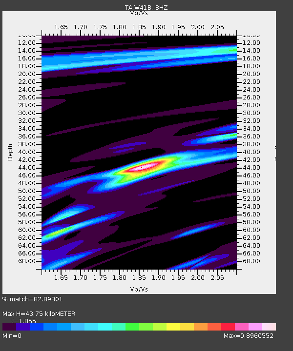
| Estimated Moho Depth: |
43.75 km |
| Estimated Crust Vp/Vs: |
1.86 |
| Assumed Crust Vp: |
6.498 km/s |
| Estimated Crust Vs: |
3.503 km/s |
| Estimated Crust Poisson's Ratio: |
0.30 |
|
| Radial Match: |
82.89801 % |
| Radial Bump: |
400 |
| Transverse Match: |
69.66605 % |
| Transverse Bump: |
400 |
| SOD ConfigId: |
6980671 |
| Insert Time: |
2019-04-16 11:41:25.250 +0000 |
| GWidth: |
2.5 |
| Max Bumps: |
400 |
| Tol: |
0.001 |
|

Signal To Noise
| Channel | StoN | STA | LTA |
| TA:W41B: :BHZ:20150202T11:00:19.150012Z | 16.658848 | 3.6816054E-6 | 2.21E-7 |
| TA:W41B: :BHN:20150202T11:00:19.150012Z | 4.561948 | 1.1459912E-6 | 2.5120656E-7 |
| TA:W41B: :BHE:20150202T11:00:19.150012Z | 2.5179515 | 4.773542E-7 | 1.8958038E-7 |
| Arrivals |
| Ps | 6.0 SECOND |
| PpPs | 19 SECOND |
| PsPs/PpSs | 25 SECOND |


