You are here: Home > Network List > TA - USArray Transportable Network (new EarthScope stations) Stations List
> Station X43A Marvell, AR, USA > Earthquake Result Viewer
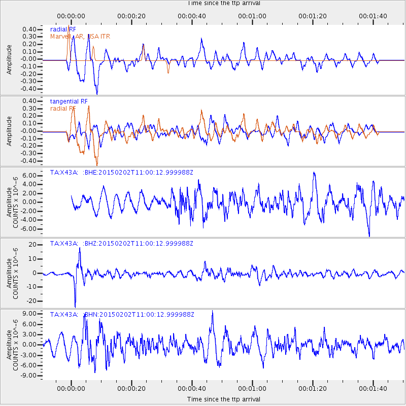
X43A Marvell, AR, USA - Earthquake Result Viewer
*The percent match for this event was below the threshold and hence no stack was calculated.
| Earthquake location: |
Mendoza Province, Argentina |
| Earthquake latitude/longitude: |
-32.7/-67.1 |
| Earthquake time(UTC): |
2015/02/02 (033) 10:49:48 GMT |
| Earthquake Depth: |
172 km |
| Earthquake Magnitude: |
6.3 MO |
| Earthquake Catalog/Contributor: |
NEIC PDE/NEIC ALERT |
|
| Network: |
TA USArray Transportable Network (new EarthScope stations) |
| Station: |
X43A Marvell, AR, USA |
| Lat/Lon: |
34.52 N/90.88 W |
| Elevation: |
53 m |
|
| Distance: |
70.5 deg |
| Az: |
339.286 deg |
| Baz: |
158.831 deg |
| Ray Param: |
$rayparam |
*The percent match for this event was below the threshold and hence was not used in the summary stack. |
|
| Radial Match: |
82.000275 % |
| Radial Bump: |
400 |
| Transverse Match: |
50.238987 % |
| Transverse Bump: |
400 |
| SOD ConfigId: |
6980671 |
| Insert Time: |
2019-04-16 11:41:40.058 +0000 |
| GWidth: |
2.5 |
| Max Bumps: |
400 |
| Tol: |
0.001 |
|
Signal To Noise
| Channel | StoN | STA | LTA |
| TA:X43A: :BHZ:20150202T11:00:12.999988Z | 13.77958 | 8.170429E-6 | 5.9293745E-7 |
| TA:X43A: :BHN:20150202T11:00:12.999988Z | 3.5380123 | 4.07269E-6 | 1.1511238E-6 |
| TA:X43A: :BHE:20150202T11:00:12.999988Z | 0.9787182 | 1.6242141E-6 | 1.6595319E-6 |
| Arrivals |
| Ps | |
| PpPs | |
| PsPs/PpSs | |


