You are here: Home > Network List > N4 - Central and EAstern US Network Stations List
> Station L40A Anamosa, IA, USA > Earthquake Result Viewer
L40A Anamosa, IA, USA - Earthquake Result Viewer
| Earthquake location: |
Near Coast Of Northern Chile |
| Earthquake latitude/longitude: |
-20.2/-70.9 |
| Earthquake time(UTC): |
2014/04/07 (097) 13:43:20 GMT |
| Earthquake Depth: |
7.9 km |
| Earthquake Magnitude: |
5.8 MWB, 5.7 MWW, 5.7 MWC |
| Earthquake Catalog/Contributor: |
NEIC PDE/NEIC COMCAT |
|
| Network: |
N4 Central and EAstern US Network |
| Station: |
L40A Anamosa, IA, USA |
| Lat/Lon: |
42.06 N/91.22 W |
| Elevation: |
242 m |
|
| Distance: |
64.7 deg |
| Az: |
343.353 deg |
| Baz: |
158.811 deg |
| Ray Param: |
0.05875491 |
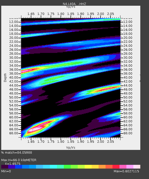
| Estimated Moho Depth: |
66.0 km |
| Estimated Crust Vp/Vs: |
1.66 |
| Assumed Crust Vp: |
6.53 km/s |
| Estimated Crust Vs: |
3.94 km/s |
| Estimated Crust Poisson's Ratio: |
0.21 |
|
| Radial Match: |
84.05988 % |
| Radial Bump: |
371 |
| Transverse Match: |
63.615837 % |
| Transverse Bump: |
400 |
| SOD ConfigId: |
626651 |
| Insert Time: |
2014-04-22 11:21:09.858 +0000 |
| GWidth: |
2.5 |
| Max Bumps: |
400 |
| Tol: |
0.001 |
|

Signal To Noise
| Channel | StoN | STA | LTA |
| N4:L40A: :HHZ:20140407T13:53:28.170007Z | 3.5683777 | 6.7805973E-7 | 1.9001905E-7 |
| N4:L40A: :HHN:20140407T13:53:28.170007Z | 2.1856759 | 3.3771906E-7 | 1.5451471E-7 |
| N4:L40A: :HHE:20140407T13:53:28.170007Z | 2.1902578 | 2.0070196E-7 | 9.163394E-8 |
| Arrivals |
| Ps | 7.0 SECOND |
| PpPs | 26 SECOND |
| PsPs/PpSs | 33 SECOND |


