You are here: Home > Network List > TA - USArray Transportable Network (new EarthScope stations) Stations List
> Station K46A Dorr, MI, USA > Earthquake Result Viewer
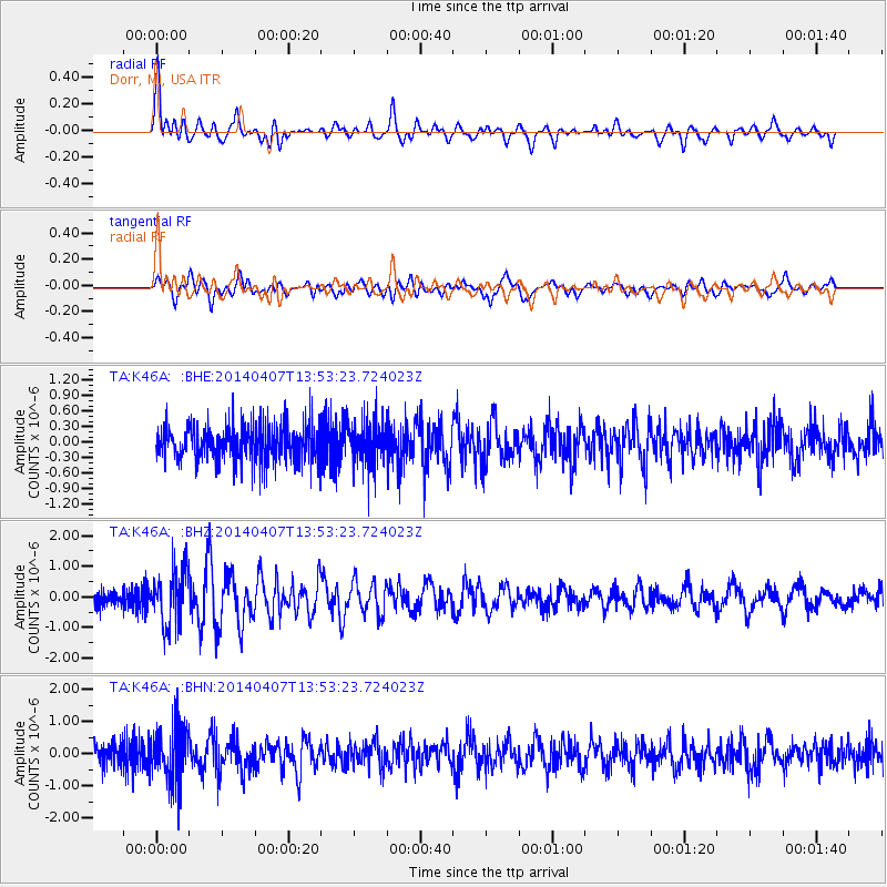
K46A Dorr, MI, USA - Earthquake Result Viewer
*The percent match for this event was below the threshold and hence no stack was calculated.
| Earthquake location: |
Near Coast Of Northern Chile |
| Earthquake latitude/longitude: |
-20.2/-70.9 |
| Earthquake time(UTC): |
2014/04/07 (097) 13:43:20 GMT |
| Earthquake Depth: |
7.9 km |
| Earthquake Magnitude: |
5.8 MWB, 5.7 MWW, 5.7 MWC |
| Earthquake Catalog/Contributor: |
NEIC PDE/NEIC COMCAT |
|
| Network: |
TA USArray Transportable Network (new EarthScope stations) |
| Station: |
K46A Dorr, MI, USA |
| Lat/Lon: |
42.69 N/85.78 W |
| Elevation: |
213 m |
|
| Distance: |
64.0 deg |
| Az: |
347.812 deg |
| Baz: |
164.395 deg |
| Ray Param: |
$rayparam |
*The percent match for this event was below the threshold and hence was not used in the summary stack. |
|
| Radial Match: |
63.187553 % |
| Radial Bump: |
400 |
| Transverse Match: |
67.14123 % |
| Transverse Bump: |
400 |
| SOD ConfigId: |
626651 |
| Insert Time: |
2014-04-22 11:33:14.867 +0000 |
| GWidth: |
2.5 |
| Max Bumps: |
400 |
| Tol: |
0.001 |
|
Signal To Noise
| Channel | StoN | STA | LTA |
| TA:K46A: :BHZ:20140407T13:53:23.724023Z | 3.6861155 | 8.921653E-7 | 2.4203402E-7 |
| TA:K46A: :BHN:20140407T13:53:23.724023Z | 1.9980544 | 8.500523E-7 | 4.2544002E-7 |
| TA:K46A: :BHE:20140407T13:53:23.724023Z | 1.2084321 | 4.2772493E-7 | 3.5395033E-7 |
| Arrivals |
| Ps | |
| PpPs | |
| PsPs/PpSs | |


