You are here: Home > Network List > TA - USArray Transportable Network (new EarthScope stations) Stations List
> Station L54A Sinclairville, NY, USA > Earthquake Result Viewer
L54A Sinclairville, NY, USA - Earthquake Result Viewer

| Earthquake location: |
Near Coast Of Northern Chile |
| Earthquake latitude/longitude: |
-20.2/-70.9 |
| Earthquake time(UTC): |
2014/04/07 (097) 13:43:20 GMT |
| Earthquake Depth: |
7.9 km |
| Earthquake Magnitude: |
5.8 MWB, 5.7 MWW, 5.7 MWC |
| Earthquake Catalog/Contributor: |
NEIC PDE/NEIC COMCAT |
|
| Network: |
TA USArray Transportable Network (new EarthScope stations) |
| Station: |
L54A Sinclairville, NY, USA |
| Lat/Lon: |
42.23 N/79.32 W |
| Elevation: |
432 m |
|
| Distance: |
62.6 deg |
| Az: |
352.938 deg |
| Baz: |
171.052 deg |
| Ray Param: |
0.060146533 |
| Estimated Moho Depth: |
15.75 km |
| Estimated Crust Vp/Vs: |
1.60 |
| Assumed Crust Vp: |
6.419 km/s |
| Estimated Crust Vs: |
4.012 km/s |
| Estimated Crust Poisson's Ratio: |
0.18 |
|
| Radial Match: |
86.68844 % |
| Radial Bump: |
400 |
| Transverse Match: |
67.05548 % |
| Transverse Bump: |
400 |
| SOD ConfigId: |
626651 |
| Insert Time: |
2014-04-22 11:34:26.431 +0000 |
| GWidth: |
2.5 |
| Max Bumps: |
400 |
| Tol: |
0.001 |
|
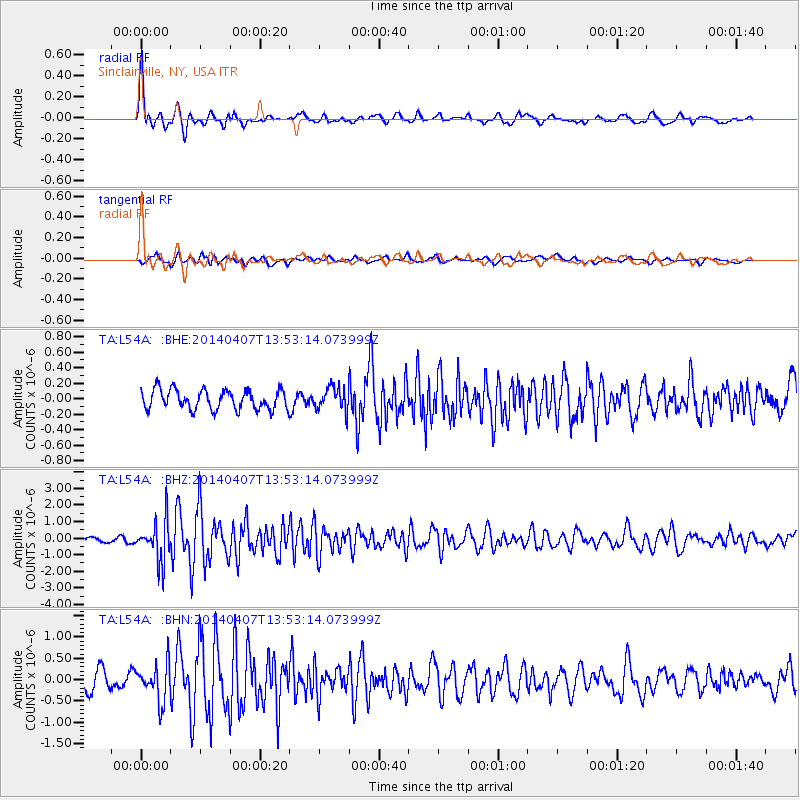
Signal To Noise
| Channel | StoN | STA | LTA |
| TA:L54A: :BHZ:20140407T13:53:14.073999Z | 7.3027606 | 1.2115421E-6 | 1.6590194E-7 |
| TA:L54A: :BHN:20140407T13:53:14.073999Z | 2.129378 | 4.316084E-7 | 2.0269225E-7 |
| TA:L54A: :BHE:20140407T13:53:14.073999Z | 1.2145921 | 1.533282E-7 | 1.2623843E-7 |
| Arrivals |
| Ps | 1.5 SECOND |
| PpPs | 6.1 SECOND |
| PsPs/PpSs | 7.6 SECOND |


