You are here: Home > Network List > TA - USArray Transportable Network (new EarthScope stations) Stations List
> Station L56A Greenwood, NY, USA > Earthquake Result Viewer
L56A Greenwood, NY, USA - Earthquake Result Viewer
| Earthquake location: |
Near Coast Of Northern Chile |
| Earthquake latitude/longitude: |
-20.2/-70.9 |
| Earthquake time(UTC): |
2014/04/07 (097) 13:43:20 GMT |
| Earthquake Depth: |
7.9 km |
| Earthquake Magnitude: |
5.8 MWB, 5.7 MWW, 5.7 MWC |
| Earthquake Catalog/Contributor: |
NEIC PDE/NEIC COMCAT |
|
| Network: |
TA USArray Transportable Network (new EarthScope stations) |
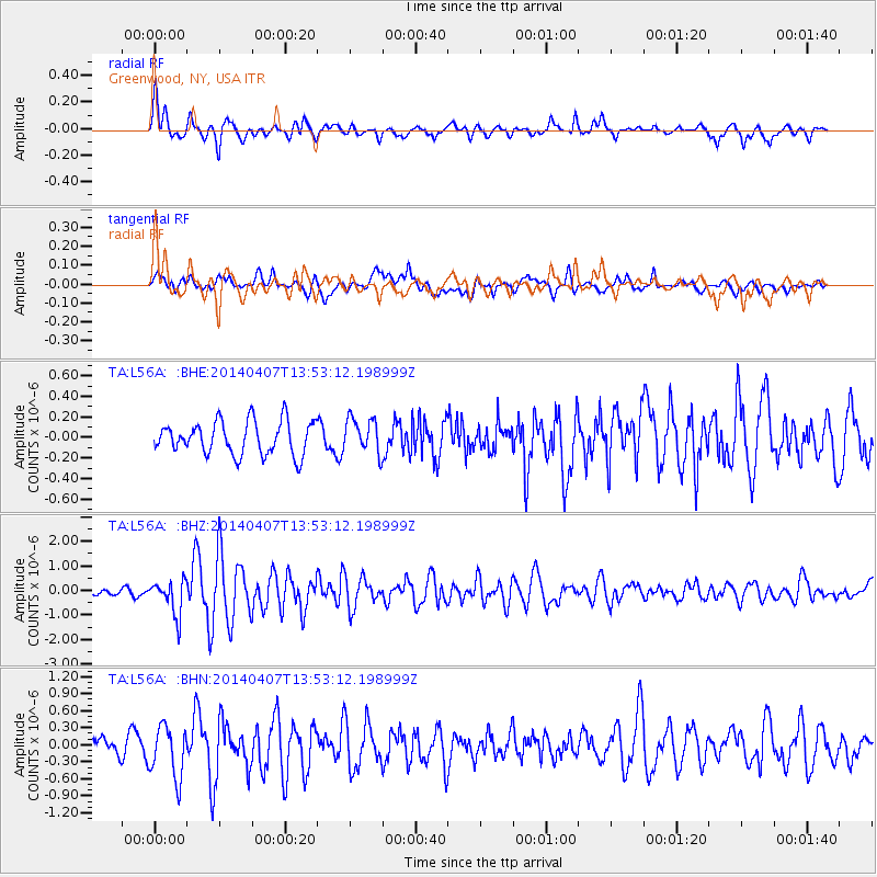
| Station: |
L56A Greenwood, NY, USA |
| Lat/Lon: |
42.14 N/77.56 W |
| Elevation: |
688 m |
|
| Distance: |
62.3 deg |
| Az: |
354.381 deg |
| Baz: |
172.896 deg |
| Ray Param: |
0.060331415 |
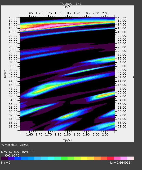
| Estimated Moho Depth: |
16.5 km |
| Estimated Crust Vp/Vs: |
1.63 |
| Assumed Crust Vp: |
6.476 km/s |
| Estimated Crust Vs: |
3.979 km/s |
| Estimated Crust Poisson's Ratio: |
0.20 |
|
| Radial Match: |
82.49568 % |
| Radial Bump: |
351 |
| Transverse Match: |
63.50629 % |
| Transverse Bump: |
400 |
| SOD ConfigId: |
626651 |
| Insert Time: |
2014-04-22 11:34:31.689 +0000 |
| GWidth: |
2.5 |
| Max Bumps: |
400 |
| Tol: |
0.001 |
|
Signal To Noise
| Channel | StoN | STA | LTA |
| TA:L56A: :BHZ:20140407T13:53:12.198999Z | 3.210672 | 6.976739E-7 | 2.1729839E-7 |
| TA:L56A: :BHN:20140407T13:53:12.198999Z | 3.1916845 | 4.5589368E-7 | 1.4283796E-7 |
| TA:L56A: :BHE:20140407T13:53:12.198999Z | 1.0685517 | 1.712616E-7 | 1.6027451E-7 |
| Arrivals |
| Ps | 1.7 SECOND |
| PpPs | 6.4 SECOND |
| PsPs/PpSs | 8.1 SECOND |


