You are here: Home > Network List > TA - USArray Transportable Network (new EarthScope stations) Stations List
> Station MDND Maddock, ND, USA > Earthquake Result Viewer
MDND Maddock, ND, USA - Earthquake Result Viewer
| Earthquake location: |
Near Coast Of Northern Chile |
| Earthquake latitude/longitude: |
-20.2/-70.9 |
| Earthquake time(UTC): |
2014/04/07 (097) 13:43:20 GMT |
| Earthquake Depth: |
7.9 km |
| Earthquake Magnitude: |
5.8 MWB, 5.7 MWW, 5.7 MWC |
| Earthquake Catalog/Contributor: |
NEIC PDE/NEIC COMCAT |
|
| Network: |
TA USArray Transportable Network (new EarthScope stations) |
| Station: |
MDND Maddock, ND, USA |
| Lat/Lon: |
47.85 N/99.60 W |
| Elevation: |
479 m |
|
| Distance: |
72.4 deg |
| Az: |
340.144 deg |
| Baz: |
151.721 deg |
| Ray Param: |
0.053662486 |
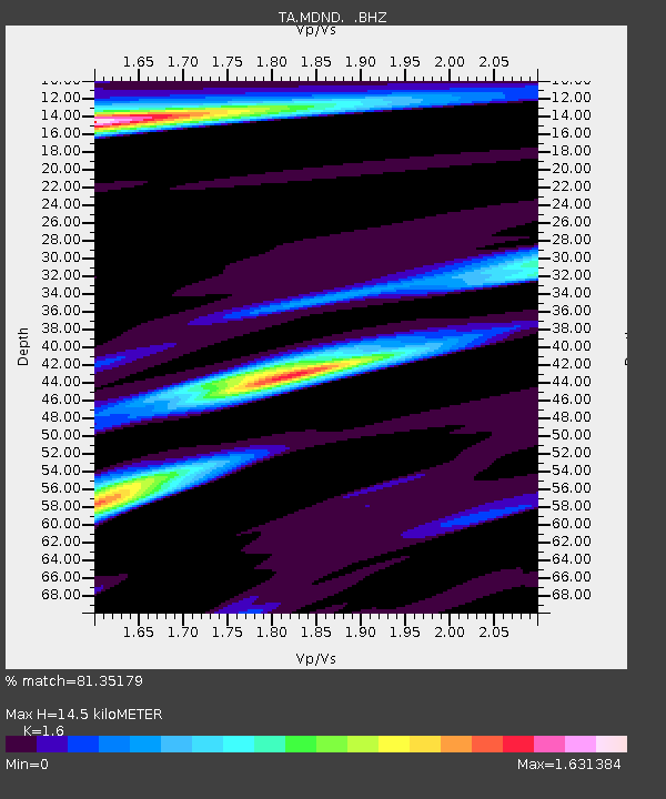
| Estimated Moho Depth: |
14.5 km |
| Estimated Crust Vp/Vs: |
1.60 |
| Assumed Crust Vp: |
6.53 km/s |
| Estimated Crust Vs: |
4.082 km/s |
| Estimated Crust Poisson's Ratio: |
0.18 |
|
| Radial Match: |
81.35179 % |
| Radial Bump: |
400 |
| Transverse Match: |
70.62212 % |
| Transverse Bump: |
400 |
| SOD ConfigId: |
626651 |
| Insert Time: |
2014-04-22 11:35:51.786 +0000 |
| GWidth: |
2.5 |
| Max Bumps: |
400 |
| Tol: |
0.001 |
|
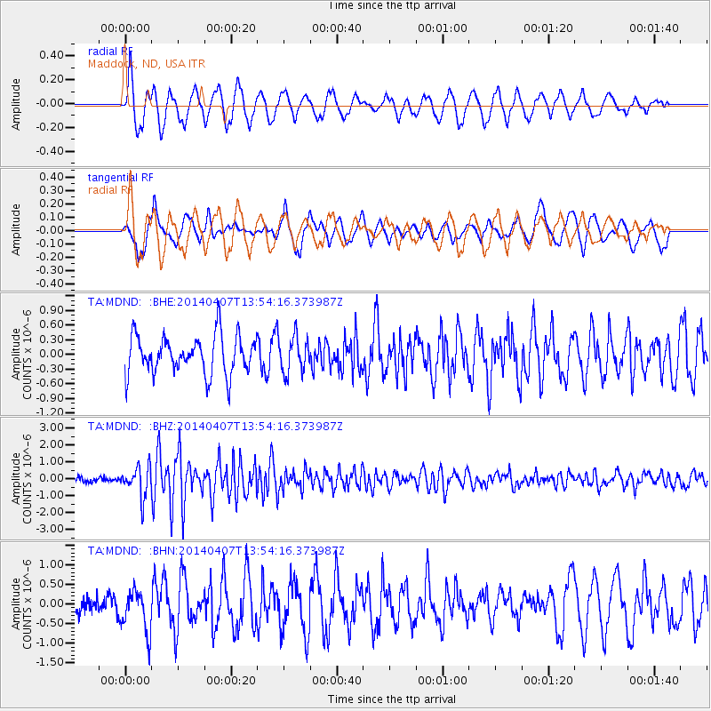
Signal To Noise
| Channel | StoN | STA | LTA |
| TA:MDND: :BHZ:20140407T13:54:16.373987Z | 6.098319 | 9.0837233E-7 | 1.4895454E-7 |
| TA:MDND: :BHN:20140407T13:54:16.373987Z | 1.7661072 | 5.2574615E-7 | 2.9768646E-7 |
| TA:MDND: :BHE:20140407T13:54:16.373987Z | 0.915974 | 3.6214627E-7 | 3.953674E-7 |
| Arrivals |
| Ps | 1.4 SECOND |
| PpPs | 5.5 SECOND |
| PsPs/PpSs | 6.9 SECOND |


