You are here: Home > Network List > TA - USArray Transportable Network (new EarthScope stations) Stations List
> Station R57A Stanardsville, VA, USA > Earthquake Result Viewer
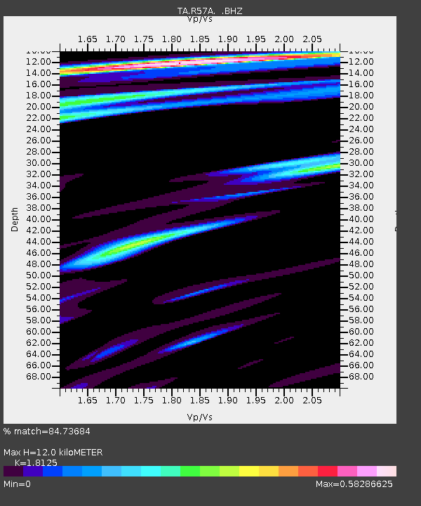
R57A Stanardsville, VA, USA - Earthquake Result Viewer
| Earthquake location: |
Near Coast Of Northern Chile |
| Earthquake latitude/longitude: |
-20.2/-70.9 |
| Earthquake time(UTC): |
2014/04/07 (097) 13:43:20 GMT |
| Earthquake Depth: |
7.9 km |
| Earthquake Magnitude: |
5.8 MWB, 5.7 MWW, 5.7 MWC |
| Earthquake Catalog/Contributor: |
NEIC PDE/NEIC COMCAT |
|
| Network: |
TA USArray Transportable Network (new EarthScope stations) |
| Station: |
R57A Stanardsville, VA, USA |
| Lat/Lon: |
38.30 N/78.52 W |
| Elevation: |
230 m |
|
| Distance: |
58.6 deg |
| Az: |
352.945 deg |
| Baz: |
171.566 deg |
| Ray Param: |
0.06275282 |
| Estimated Moho Depth: |
12.0 km |
| Estimated Crust Vp/Vs: |
1.81 |
| Assumed Crust Vp: |
6.159 km/s |
| Estimated Crust Vs: |
3.398 km/s |
| Estimated Crust Poisson's Ratio: |
0.28 |
|
| Radial Match: |
84.73684 % |
| Radial Bump: |
400 |
| Transverse Match: |
67.821365 % |
| Transverse Bump: |
400 |
| SOD ConfigId: |
626651 |
| Insert Time: |
2014-04-22 11:38:46.356 +0000 |
| GWidth: |
2.5 |
| Max Bumps: |
400 |
| Tol: |
0.001 |
|

Signal To Noise
| Channel | StoN | STA | LTA |
| TA:R57A: :BHZ:20140407T13:52:46.975Z | 3.4100168 | 6.490157E-7 | 1.9032625E-7 |
| TA:R57A: :BHN:20140407T13:52:46.975Z | 2.9864454 | 3.1971342E-7 | 1.0705484E-7 |
| TA:R57A: :BHE:20140407T13:52:46.975Z | 0.93099475 | 1.2549307E-7 | 1.347946E-7 |
| Arrivals |
| Ps | 1.7 SECOND |
| PpPs | 5.2 SECOND |
| PsPs/PpSs | 6.9 SECOND |


