You are here: Home > Network List > TA - USArray Transportable Network (new EarthScope stations) Stations List
> Station T51A Gray, KY, USA > Earthquake Result Viewer
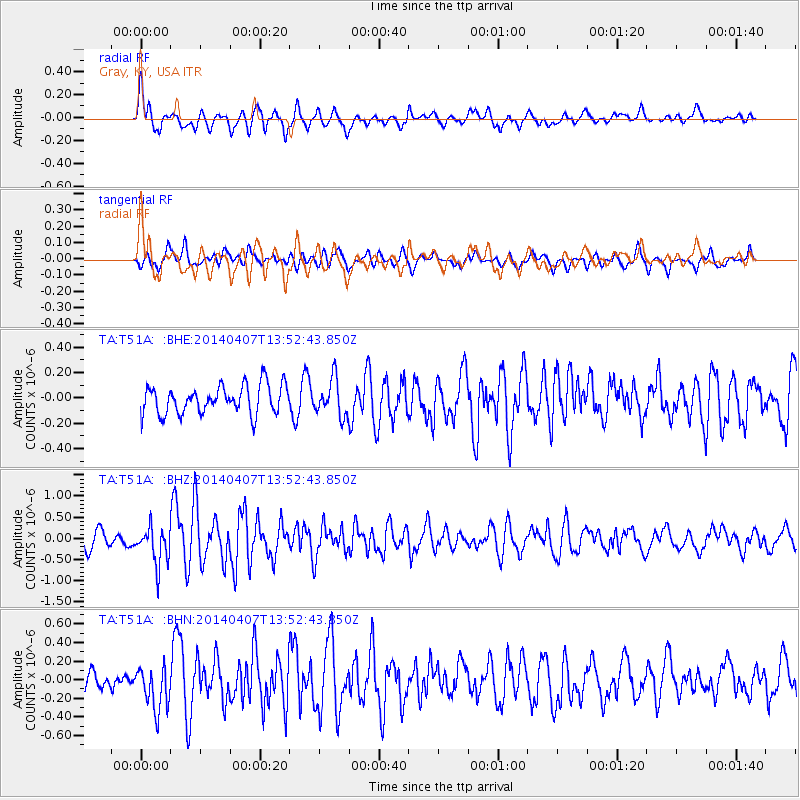
T51A Gray, KY, USA - Earthquake Result Viewer
*The percent match for this event was below the threshold and hence no stack was calculated.
| Earthquake location: |
Near Coast Of Northern Chile |
| Earthquake latitude/longitude: |
-20.2/-70.9 |
| Earthquake time(UTC): |
2014/04/07 (097) 13:43:20 GMT |
| Earthquake Depth: |
7.9 km |
| Earthquake Magnitude: |
5.8 MWB, 5.7 MWW, 5.7 MWC |
| Earthquake Catalog/Contributor: |
NEIC PDE/NEIC COMCAT |
|
| Network: |
TA USArray Transportable Network (new EarthScope stations) |
| Station: |
T51A Gray, KY, USA |
| Lat/Lon: |
36.97 N/83.95 W |
| Elevation: |
329 m |
|
| Distance: |
58.1 deg |
| Az: |
347.679 deg |
| Baz: |
165.505 deg |
| Ray Param: |
$rayparam |
*The percent match for this event was below the threshold and hence was not used in the summary stack. |
|
| Radial Match: |
72.46602 % |
| Radial Bump: |
400 |
| Transverse Match: |
63.09969 % |
| Transverse Bump: |
400 |
| SOD ConfigId: |
626651 |
| Insert Time: |
2014-04-22 11:39:41.289 +0000 |
| GWidth: |
2.5 |
| Max Bumps: |
400 |
| Tol: |
0.001 |
|
Signal To Noise
| Channel | StoN | STA | LTA |
| TA:T51A: :BHZ:20140407T13:52:43.850Z | 2.134588 | 4.5363606E-7 | 2.1251691E-7 |
| TA:T51A: :BHN:20140407T13:52:43.850Z | 1.8768617 | 2.4356322E-7 | 1.2977154E-7 |
| TA:T51A: :BHE:20140407T13:52:43.850Z | 1.2849098 | 1.4428352E-7 | 1.1229078E-7 |
| Arrivals |
| Ps | |
| PpPs | |
| PsPs/PpSs | |


