You are here: Home > Network List > TA - USArray Transportable Network (new EarthScope stations) Stations List
> Station V60A Jim Taylor Road, Stokes, NC, USA > Earthquake Result Viewer
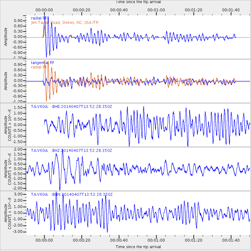
V60A Jim Taylor Road, Stokes, NC, USA - Earthquake Result Viewer
*The percent match for this event was below the threshold and hence no stack was calculated.
| Earthquake location: |
Near Coast Of Northern Chile |
| Earthquake latitude/longitude: |
-20.2/-70.9 |
| Earthquake time(UTC): |
2014/04/07 (097) 13:43:20 GMT |
| Earthquake Depth: |
7.9 km |
| Earthquake Magnitude: |
5.8 MWB, 5.7 MWW, 5.7 MWC |
| Earthquake Catalog/Contributor: |
NEIC PDE/NEIC COMCAT |
|
| Network: |
TA USArray Transportable Network (new EarthScope stations) |
| Station: |
V60A Jim Taylor Road, Stokes, NC, USA |
| Lat/Lon: |
35.76 N/77.26 W |
| Elevation: |
8.0 m |
|
| Distance: |
55.9 deg |
| Az: |
353.722 deg |
| Baz: |
172.743 deg |
| Ray Param: |
$rayparam |
*The percent match for this event was below the threshold and hence was not used in the summary stack. |
|
| Radial Match: |
78.02533 % |
| Radial Bump: |
400 |
| Transverse Match: |
68.1533 % |
| Transverse Bump: |
400 |
| SOD ConfigId: |
626651 |
| Insert Time: |
2014-04-22 11:40:42.890 +0000 |
| GWidth: |
2.5 |
| Max Bumps: |
400 |
| Tol: |
0.001 |
|
Signal To Noise
| Channel | StoN | STA | LTA |
| TA:V60A: :BHZ:20140407T13:52:28.350Z | 2.3275292 | 6.0225216E-7 | 2.5875173E-7 |
| TA:V60A: :BHN:20140407T13:52:28.350Z | 2.2097807 | 1.1696154E-6 | 5.292903E-7 |
| TA:V60A: :BHE:20140407T13:52:28.350Z | 1.1179154 | 4.9907817E-7 | 4.4643642E-7 |
| Arrivals |
| Ps | |
| PpPs | |
| PsPs/PpSs | |


