You are here: Home > Network List > II - Global Seismograph Network (GSN - IRIS/IDA) Stations List
> Station DGAR Diego Garcia, Chagos Islands, Indian Ocean > Earthquake Result Viewer
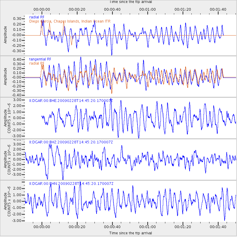
DGAR Diego Garcia, Chagos Islands, Indian Ocean - Earthquake Result Viewer
*The percent match for this event was below the threshold and hence no stack was calculated.
| Earthquake location: |
South Sandwich Islands Region |
| Earthquake latitude/longitude: |
-60.5/-24.8 |
| Earthquake time(UTC): |
2009/02/28 (059) 14:33:06 GMT |
| Earthquake Depth: |
15 km |
| Earthquake Magnitude: |
6.1 MB, 6.1 MS, 6.3 MW, 6.3 MW |
| Earthquake Catalog/Contributor: |
WHDF/NEIC |
|
| Network: |
II Global Seismograph Network (GSN - IRIS/IDA) |
| Station: |
DGAR Diego Garcia, Chagos Islands, Indian Ocean |
| Lat/Lon: |
7.41 S/72.45 E |
| Elevation: |
1.0 m |
|
| Distance: |
87.2 deg |
| Az: |
99.924 deg |
| Baz: |
209.42 deg |
| Ray Param: |
$rayparam |
*The percent match for this event was below the threshold and hence was not used in the summary stack. |
|
| Radial Match: |
61.947357 % |
| Radial Bump: |
400 |
| Transverse Match: |
64.13543 % |
| Transverse Bump: |
400 |
| SOD ConfigId: |
2658 |
| Insert Time: |
2010-03-01 20:27:41.141 +0000 |
| GWidth: |
2.5 |
| Max Bumps: |
400 |
| Tol: |
0.001 |
|
Signal To Noise
| Channel | StoN | STA | LTA |
| II:DGAR:00:BHZ:20090228T14:45:20.170007Z | 2.9956071 | 2.00626E-6 | 6.6973405E-7 |
| II:DGAR:00:BHN:20090228T14:45:20.170007Z | 1.4504718 | 1.2855537E-6 | 8.863004E-7 |
| II:DGAR:00:BHE:20090228T14:45:20.170007Z | 0.80221975 | 7.7395356E-7 | 9.64765E-7 |
| Arrivals |
| Ps | |
| PpPs | |
| PsPs/PpSs | |


